

Bus 96 in Birmingham links Birmingham International Station and Kingstanding Circle. The route is 31.4 km long with 81 stops, and the official schedule from National Express West Midlands puts the full trip at about 70 minutes. On a weekday it runs 33 trips in one direction, and 19 on a weekend day.
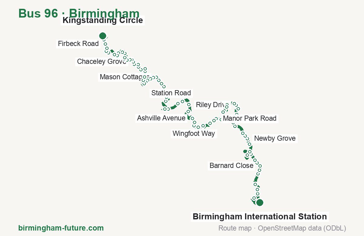
Route at a glance
| Mode | Bus |
|---|---|
| Route number | 96 |
| City | Birmingham |
| Operator | National Express West Midlands |
| Start → end | Birmingham International Station → Kingstanding Circle |
| End → start | Kingstanding Circle → Birmingham International Station |
| Route length | 31.4 km / 31.9 km in the opposite direction |
| Number of stops | 81 / 83 in the opposite direction |
| Travel time | about 70 minutes |
| Trips per day | 33 on weekdays, 19 on weekends one way |
| Frequency | peak 30–35 · midday 30–35 · weekend 60–70 |
| First / last trip from «Birmingham International Station» | 04:10 / 23:25 |
| First / last trip from «Kingstanding Circle» | 02:46 / 22:45 |
| Fare | 3.00 £ (fare in effect since 28 June 2026) |
| Updated | August 22, 2026 |
Route of Bus 96
Outbound: Birmingham International Station → Kingstanding Circle
This direction has 81 stops and runs 31.4 km. The route passes Birmingham Airport Bus Terminal, Wolseley Close, Dunlop Way, Steel Maitland Avenue. Below is the full list with the distance from the first stop.
| No. | Stop | From start | Note |
|---|---|---|---|
| 1 | Birmingham International Station | 0.0 km | Terminus |
| 2 | Birmingham Airport Bus Terminal | 1.2 km | |
| 3 | Morris Way | 2.1 km | |
| 4 | Elmdon Trading Estate | 2.4 km | |
| 5 | Bickenhill Lane | 2.9 km | |
| 6 | Coleshill Road | 3.6 km | |
| 7 | Heath Farm | 3.9 km | |
| 8 | Barnard Close | 4.3 km | |
| 9 | Dunster Road | 4.6 km | |
| 10 | Carisbrooke Avenue | 4.8 km | |
| 11 | Hedgetree Croft | 5.3 km | |
| 12 | Chelmsley Interchange | 6.0 km | |
| 13 | Meriden Park | 6.9 km | |
| 14 | Clopton Crescent | 7.5 km | |
| 15 | Newby Grove | 7.9 km | |
| 16 | Bacons End Island | 8.1 km | |
| 17 | Woodlands Green | 8.4 km | |
| 18 | Overgreen Drive | 9.2 km | |
| 19 | Chester Road | 9.6 km | |
| 20 | Village Centre | 10.3 km | |
| 21 | Wolseley Close | 10.8 km | |
| 22 | Riley Drive | 11.1 km | |
| 23 | Rover Drive | 11.3 km | |
| 24 | Singer Croft | 11.9 km | |
| 25 | Morris Croft | 12.0 km | |
| 26 | Clevedon Avenue | 12.4 km | |
| 27 | Springfield Road | 12.6 km | |
| 28 | Henshaw Court | 13.2 km | |
| 29 | Manor Park Road | 13.6 km | |
| 30 | Thistledown Road | 13.8 km | |
| 31 | Hawcroft Grove | 14.2 km | |
| 32 | School Lane | 14.8 km | |
| 33 | Bridgeford Road | 15.2 km | |
| 34 | Haxby Avenue | 15.6 km | |
| 35 | The Kingfisher | 15.9 km | |
| 36 | Ashville Avenue | 16.2 km | |
| 37 | Berrandale Gardens | 17.1 km | |
| 38 | Tameside Drive | 17.7 km | |
| 39 | Fort Industrial Estate | 18.3 km | |
| 40 | Dunlop Way | 18.7 km | |
| 41 | Sytner Car Dealerships | 19.5 km | |
| 42 | Fort Shopping Centre | 20.0 km | |
| 43 | Wingfoot Way | 20.9 km | |
| 44 | Spitfire Road | 21.3 km | |
| 45 | Tyburn Road | 21.6 km | |
| 46 | Quincey Drive | 22.0 km | |
| 47 | Woodacre Road | 22.2 km | |
| 48 | Allman Road | 22.5 km | |
| 49 | Moor End Lane | 22.8 km | |
| 50 | Mason Cottages | 23.1 km | |
| 51 | Hart Road | 23.3 km | |
| 52 | Erdington Fire Station | 23.6 km | |
| 53 | New Street | 23.8 km | |
| 54 | Barnabas Road | 24.0 km | |
| 55 | Six Ways Island | 24.1 km | |
| 56 | Machin Road | 24.6 km | |
| 57 | Station Road | 24.8 km | |
| 58 | Somerset Road | 25.2 km | |
| 59 | Steel Maitland Avenue | 25.5 km | |
| 60 | St Margarets Church | 25.8 km | |
| 61 | Madehurst Road | 26.1 km | |
| 62 | Jerry’s Lane | 26.2 km | |
| 63 | Chipstead Road | 26.6 km | |
| 64 | Chaceley Grove | 26.8 km | |
| 65 | Abbeyfield Road | 27.0 km | |
| 66 | Sheddington Road | 27.1 km | |
| 67 | Turfpits Lane | 27.3 km | |
| 68 | Witton Lodge Road | 27.5 km | |
| 69 | Maxted Road | 27.7 km | |
| 70 | Archers Close | 28.0 km | |
| 71 | Hurstwood Road | 28.3 km | |
| 72 | Epsom Grove | 28.7 km | |
| 73 | Brackenbury Road | 28.9 km | |
| 74 | Plumstead Road | 29.1 km | |
| 75 | Danesbury Crescent | 29.7 km | |
| 76 | Hurlingham Road | 29.9 km | |
| 77 | Sidcup Road | 30.2 km | |
| 78 | Firbeck Road | 30.5 km | |
| 79 | Balham Grove | 30.8 km | |
| 80 | Kingstanding Circle Eastside | 31.2 km | |
| 81 | Kingstanding Circle | 31.4 km | Terminus |
Inbound: Kingstanding Circle → Birmingham International Station
This direction has 83 stops and runs 31.9 km. The route passes Balham Grove, Madehurst Road, Dunlop Way, Riley Drive. Below is the full list with the distance from the first stop.
| No. | Stop | From start | Note |
|---|---|---|---|
| 1 | Kingstanding Circle Eastside | 0.0 km | Terminus |
| 2 | Balham Grove | 0.6 km | |
| 3 | Firbeck Road | 0.8 km | |
| 4 | Sidcup Road | 1.2 km | |
| 5 | Hurlingham Road | 1.4 km | |
| 6 | RC Primary School | 1.8 km | |
| 7 | Plumstead Road | 2.3 km | |
| 8 | Little Owl Close | 2.5 km | |
| 9 | Hales Gardens | 2.9 km | |
| 10 | Maxted Road | 3.1 km | |
| 11 | Hurstwood Road | 3.4 km | |
| 12 | Archers Close | 3.6 km | |
| 13 | Old Beeches | 3.8 km | |
| 14 | Maxted Road | 4.0 km | |
| 15 | Witton Lodge Road | 4.2 km | |
| 16 | Turfpits Lane | 4.3 km | |
| 17 | Sheddington Road | 4.5 km | |
| 18 | Abbeyfield Road | 4.6 km | |
| 19 | Chaceley Grove | 4.8 km | |
| 20 | Flackwell Road | 5.2 km | |
| 21 | Jerry’s Lane | 5.4 km | |
| 22 | Madehurst Road | 5.6 km | |
| 23 | St Margarets Church | 5.9 km | |
| 24 | Steel Maitland Avenue | 6.1 km | |
| 25 | Somerset Road | 6.4 km | |
| 26 | Station Road | 6.7 km | |
| 27 | Machin Road | 7.1 km | |
| 28 | Six Ways Island | 7.5 km | |
| 29 | Barnabas Road | 7.6 km | |
| 30 | Wilton Road | 7.9 km | |
| 31 | Erdington Fire Station | 8.1 km | |
| 32 | Mason Cottages | 8.5 km | |
| 33 | Moor End Lane | 8.8 km | |
| 34 | Allman Road | 9.1 km | |
| 35 | Woodacre Road | 9.5 km | |
| 36 | Quincey Drive | 9.8 km | |
| 37 | Kingsbury Road | 10.0 km | |
| 38 | Spitfire Road | 10.2 km | |
| 39 | Wingfoot Way | 10.8 km | |
| 40 | Fort Shopping Centre | 11.9 km | |
| 41 | Sytner Car Dealerships | 12.1 km | |
| 42 | Dunlop Way | 12.9 km | |
| 43 | Fort Industrial Estate | 13.3 km | |
| 44 | Tangmere Drive | 13.9 km | |
| 45 | Tameside Drive | 14.1 km | |
| 46 | Berrandale Gardens | 14.8 km | |
| 47 | Hernefield Road | 15.9 km | |
| 48 | The Kingfisher | 16.0 km | |
| 49 | Haxby Avenue | 16.3 km | |
| 50 | Cole Hall Lane | 16.4 km | |
| 51 | Bridgeford Road | 16.7 km | |
| 52 | Heath Way | 16.9 km | |
| 53 | School Lane | 17.1 km | |
| 54 | Hawcroft Grove | 17.7 km | |
| 55 | Manor Park Road | 18.4 km | |
| 56 | Hurst Close | 18.9 km | |
| 57 | Springfield Road | 19.3 km | |
| 58 | Clevedon Avenue | 19.5 km | |
| 59 | Morris Croft | 19.9 km | |
| 60 | Singer Croft | 20.1 km | |
| 61 | Rover Drive | 20.6 km | |
| 62 | Riley Drive | 20.8 km | |
| 63 | Wolseley Close | 21.1 km | |
| 64 | Village Centre | 21.7 km | |
| 65 | Chester Road | 22.4 km | |
| 66 | Smiths Wood School | 22.9 km | |
| 67 | Woodlands Green | 23.6 km | |
| 68 | Bacons End Island | 23.8 km | |
| 69 | Newby Grove | 24.0 km | |
| 70 | Clopton Crescent | 24.4 km | |
| 71 | Meriden Park | 25.1 km | |
| 72 | Chelmsley Interchange | 25.6 km | |
| 73 | Hedgetree Croft | 26.3 km | |
| 74 | Carisbrooke Avenue | 26.7 km | |
| 75 | Dunster Road | 26.9 km | |
| 76 | Barnard Close | 27.2 km | |
| 77 | Coleshill Road | 27.9 km | |
| 78 | Bickenhill Lane | 28.8 km | |
| 79 | Elmdon Trading Estate | 29.2 km | |
| 80 | Morris Way | 29.4 km | |
| 81 | Ingenuity House | 29.7 km | |
| 82 | Birmingham Airport Bus Terminal | 31.0 km | |
| 83 | Birmingham International Station | 31.9 km | Terminus |
Schedule and frequency
According to the official schedule from National Express West Midlands, the route runs 33 trips in one direction on a weekday, and 19 on a weekend day.
| Direction | Weekdays | Weekends and holidays |
|---|---|---|
| From «Birmingham International Station» | 04:10 — 23:25 | 04:10 — 23:25 |
| From «Kingstanding Circle» | 02:46 — 22:45 | 02:46 — 22:45 |
Frequency calculated from the departure table: in the morning peak buses run every 30–35 minutes, most often every 30; midday every 30–35 minutes; in the afternoon peak every 35–50; on weekends every 60–70 minutes.
Fare and payment
A single ride costs 3.00 £ — fare in effect since 28 June 2026. The same fare applies to National Express buses in Birmingham.
A single journey on a National Express bus costs £3.00 and is valid on one bus for one journey only — it gives no transfer. A multi-operator nBus day ticket costs £5.50 and works on every operator in the scheme.
Frequently asked questions
How much does a ride on bus 96 cost?
3.00 £ for a single ride — fare in effect since 28 June 2026.
When do the first and last trips run?
From Birmingham International Station the first is at 04:10 and the last at 23:25. From Kingstanding Circle they are 02:46 and 22:45.
How long does the trip from Birmingham International Station to Kingstanding Circle take?
About 70 minutes end to end — the median of full trips in the official schedule.
How many stops does the route have?
81 outbound and 83 inbound according to the official GTFS feed. The two lists do not match exactly.
Does bus 96 run on weekends?
Yes. On weekends and holidays there are 19 trips in one direction, running from Birmingham International Station between 04:10 and 23:25.
Every route number with its termini, operating hours and travel time is collected in the Birmingham buses overview.
Data current as of August 22, 2026. Schedule and termini — National Express West Midlands. Fares — National Express West Midlands. Stop list, schedule and route geometry come from the official GTFS feed (Bus Open Data Service (BODS)).