

Bus X51 in Birmingham links Old Square and Bus Station. The route is 31.9 km long with 58 stops, and the official schedule from National Express West Midlands puts the full trip at about 87 minutes. On a weekday it runs 90 trips in one direction, and 27 on a weekend day.
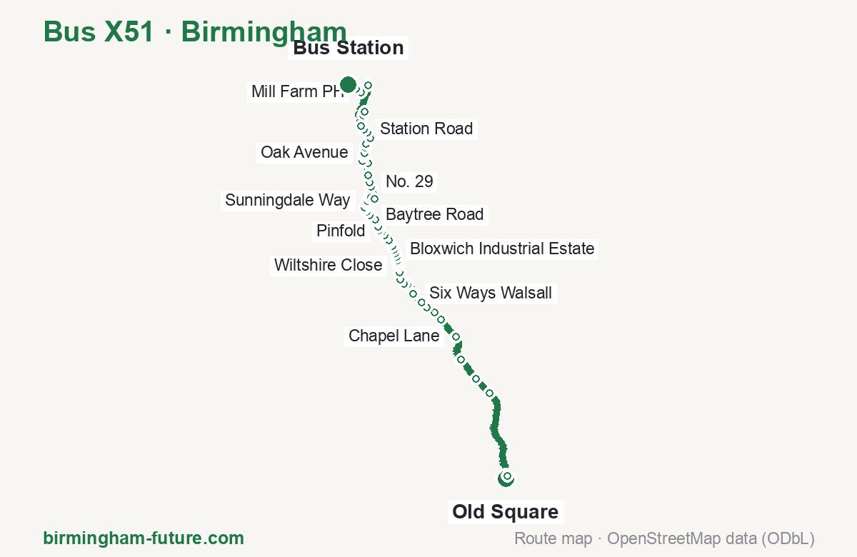
Route at a glance
| Mode | Bus |
|---|---|
| Route number | X51 |
| City | Birmingham |
| Operator | National Express West Midlands |
| Start → end | Old Square → Bus Station |
| End → start | Bus Station → Old Square |
| Route length | 31.9 km / 33.5 km in the opposite direction |
| Number of stops | 58 / 61 in the opposite direction |
| Travel time | about 87 minutes |
| Trips per day | 90 on weekdays, 27 on weekends one way (87 on weekdays → Old Square) |
| Frequency | peak 9–10 · midday 10 · weekend 5–60 |
| First / last trip from «Old Square» | 05:37 / 22:30 |
| First / last trip from «Bus Station» | 05:46 / 22:20 |
| Fare | 3.00 £ (fare in effect since 28 June 2026) |
| Updated | August 22, 2026 |
Route of Bus X51
Outbound: Old Square → Bus Station
This direction has 58 stops and runs 31.9 km. The route passes Ryder Street, Wiltshire Close, Sandbank, Enterprise Park. Below is the full list with the distance from the first stop.
| No. | Stop | From start | Note |
|---|---|---|---|
| 1 | Old Square | 0.0 km | Terminus |
| 2 | Ryder Street | 0.4 km | |
| 3 | Perry Avenue | 5.7 km | |
| 4 | Tower Hill | 6.8 km | |
| 5 | Scott Arms | 8.3 km | |
| 6 | Chapel Lane | 9.8 km | |
| 7 | Bell Road | 11.1 km | |
| 8 | Queens Road | 11.7 km | |
| 9 | Broadway | 12.3 km | |
| 10 | Jesson Road | 12.7 km | |
| 11 | Six Ways Walsall | 13.4 km | |
| 12 | Upper Bridge Street | 14.1 km | |
| 13 | Walsall Bus Station | 14.6 km | |
| 14 | Littleton St West | 15.1 km | |
| 15 | Ryecroft Street | 15.5 km | |
| 16 | Wiltshire Close | 15.8 km | |
| 17 | Northcote Street | 16.0 km | |
| 18 | Derby Street | 16.2 km | |
| 19 | Forest Lane | 16.4 km | |
| 20 | Carl Street | 16.6 km | |
| 21 | Bloxwich Industrial Estate | 16.8 km | |
| 22 | May Street | 17.1 km | |
| 23 | Comwall Close | 17.3 km | |
| 24 | Leamore Lane | 17.5 km | |
| 25 | Leamore Park | 17.9 km | |
| 26 | Pinfold | 18.1 km | |
| 27 | Bloxwich Hospital | 18.4 km | |
| 28 | Elmore Row | 18.6 km | |
| 29 | Samuel Street | 18.9 km | |
| 30 | Sandbank | 19.1 km | |
| 31 | Baytree Road | 19.6 km | |
| 32 | Broad Lane Gardens | 19.9 km | |
| 33 | Bloxwich North Station | 20.1 km | |
| 34 | Woodbridge Close | 20.2 km | |
| 35 | Gleneagles Road | 20.4 km | |
| 36 | Sunningdale Way | 20.6 km | |
| 37 | Saddleworth Road | 20.9 km | |
| 38 | Ganton Road | 21.0 km | |
| 39 | Ferndown Close | 21.3 km | |
| 40 | The Lakes | 22.2 km | |
| 41 | No. 29 | 22.4 km | |
| 42 | Long Lane | 22.9 km | |
| 43 | Fairoaks Drive | 23.6 km | |
| 44 | Enterprise Park | 24.1 km | |
| 45 | Poplar Road | 24.4 km | |
| 46 | Oak Avenue | 24.6 km | |
| 47 | Wardles Lane | 24.9 km | |
| 48 | Moat Lane | 25.2 km | |
| 49 | Appledore Close | 25.5 km | |
| 50 | Norton Lane | 26.0 km | |
| 51 | Station Road | 26.2 km | |
| 52 | Leacroft Lane | 26.5 km | |
| 53 | Sainsburys Store | 27.7 km | |
| 54 | Eastern Way | 28.0 km | |
| 55 | McArthurGlen Retail Outlet | 29.8 km | |
| 56 | Mill Farm PH | 30.8 km | |
| 57 | Hollies Park Road | 31.2 km | |
| 58 | Bus Station | 31.9 km | Terminus |
Inbound: Bus Station → Old Square
This direction has 61 stops and runs 33.5 km. The route passes Hollies Park Road, Enterprise Park, Baytree Road, Wiltshire Close. Below is the full list with the distance from the first stop.
| No. | Stop | From start | Note |
|---|---|---|---|
| 1 | Bus Station | 0.0 km | Terminus |
| 2 | Hollies Park Road | 0.8 km | |
| 3 | Mill Farm PH | 1.3 km | |
| 4 | McArthurGlen Retail Outlet | 2.0 km | |
| 5 | Eastern Way | 3.7 km | |
| 6 | Sainsburys Store | 4.3 km | |
| 7 | Eastern Way | 4.7 km | |
| 8 | Leacroft Lane | 6.0 km | |
| 9 | Station Road | 6.5 km | |
| 10 | Norton Lane | 6.7 km | |
| 11 | Appledore Close | 7.1 km | |
| 12 | Moat Lane | 7.4 km | |
| 13 | Wardles Lane | 7.8 km | |
| 14 | Oak Avenue | 8.0 km | |
| 15 | Poplar Road | 8.2 km | |
| 16 | Enterprise Park | 8.6 km | |
| 17 | Fairoaks Drive | 8.9 km | |
| 18 | Holly Lane | 9.2 km | |
| 19 | Long Lane | 9.9 km | |
| 20 | No. 29 | 10.2 km | |
| 21 | The Lakes | 10.5 km | |
| 22 | Ferndown Close | 11.4 km | |
| 23 | Ganton Road | 11.7 km | |
| 24 | Saddleworth Road | 11.8 km | |
| 25 | Sunningdale Way | 12.0 km | |
| 26 | Gleneagles Road | 12.2 km | |
| 27 | Woodbridge Close | 12.4 km | |
| 28 | Bloxwich North Station | 12.6 km | |
| 29 | Broad Lane Gardens | 12.8 km | |
| 30 | Baytree Road | 13.1 km | |
| 31 | Sandbank | 13.6 km | |
| 32 | Victoria Avenue | 13.8 km | |
| 33 | Elmore Row | 14.1 km | |
| 34 | Bloxwich Hospital | 14.3 km | |
| 35 | Pinfold | 14.5 km | |
| 36 | Leamore Park | 14.9 km | |
| 37 | Leamore Lane | 15.2 km | |
| 38 | May Street | 15.5 km | |
| 39 | Bloxwich Industrial Estate | 15.8 km | |
| 40 | Carl Street | 16.1 km | |
| 41 | Forest Lane | 16.4 km | |
| 42 | Derby Street | 16.5 km | |
| 43 | Northcote Street | 16.7 km | |
| 44 | Wiltshire Close | 16.8 km | |
| 45 | Ryecroft Street | 17.2 km | |
| 46 | Walsall Magistrates Court | 17.5 km | |
| 47 | Littleton St West | 17.6 km | |
| 48 | Hatherton Road | 18.0 km | |
| 49 | Walsall Bus Station | 18.7 km | |
| 50 | Walsall Town Hall | 19.3 km | |
| 51 | Six Ways Walsall | 20.2 km | |
| 52 | Jesson Road | 20.9 km | |
| 53 | Broadway | 21.4 km | |
| 54 | Queens Road | 21.7 km | |
| 55 | Bell Road | 22.5 km | |
| 56 | Chapel Lane | 23.7 km | |
| 57 | Scott Arms | 25.2 km | |
| 58 | Tower Hill | 26.7 km | |
| 59 | Perry Avenue | 27.7 km | |
| 60 | Dalton Street | 33.2 km | |
| 61 | Old Square | 33.5 km | Terminus |
Schedule and frequency
According to the official schedule from National Express West Midlands, the route runs 90 trips in one direction on a weekday, and 27 on a weekend day.
| Direction | Weekdays | Weekends and holidays |
|---|---|---|
| From «Old Square» | 05:37 — 22:30 | 07:45 — 20:10 |
| From «Bus Station» | 05:46 — 22:20 | 07:36 — 18:38 |
Frequency calculated from the departure table: in the morning peak buses run every 9–10 minutes, most often every 10; midday every 10 minutes; in the afternoon peak every 8–15; on weekends every 5–60 minutes.
Fare and payment
A single ride costs 3.00 £ — fare in effect since 28 June 2026. The same fare applies to National Express buses in Birmingham.
A single journey on a National Express bus costs £3.00 and is valid on one bus for one journey only — it gives no transfer. A multi-operator nBus day ticket costs £5.50 and works on every operator in the scheme.
Frequently asked questions
How much does a ride on bus X51 cost?
3.00 £ for a single ride — fare in effect since 28 June 2026.
When do the first and last trips run?
From Old Square the first is at 05:37 and the last at 22:30. From Bus Station they are 05:46 and 22:20.
How long does the trip from Old Square to Bus Station take?
About 87 minutes end to end — the median of full trips in the official schedule.
How many stops does the route have?
58 outbound and 61 inbound according to the official GTFS feed. The two lists do not match exactly.
Does bus X51 run on weekends?
Yes. On weekends and holidays there are 27 trips in one direction, running from Old Square between 07:45 and 20:10.
Every route number with its termini, operating hours and travel time is collected in the Birmingham buses overview.
Data current as of August 22, 2026. Schedule and termini — National Express West Midlands. Fares — National Express West Midlands. Stop list, schedule and route geometry come from the official GTFS feed (Bus Open Data Service (BODS)).