

Bus 77A in Birmingham links Walsall Bus Station and Six Ways Island. The route is 33.6 km long with 84 stops, and the official schedule from National Express West Midlands puts the full trip at about 91 minutes. On a weekday it runs 7 trips in one direction.
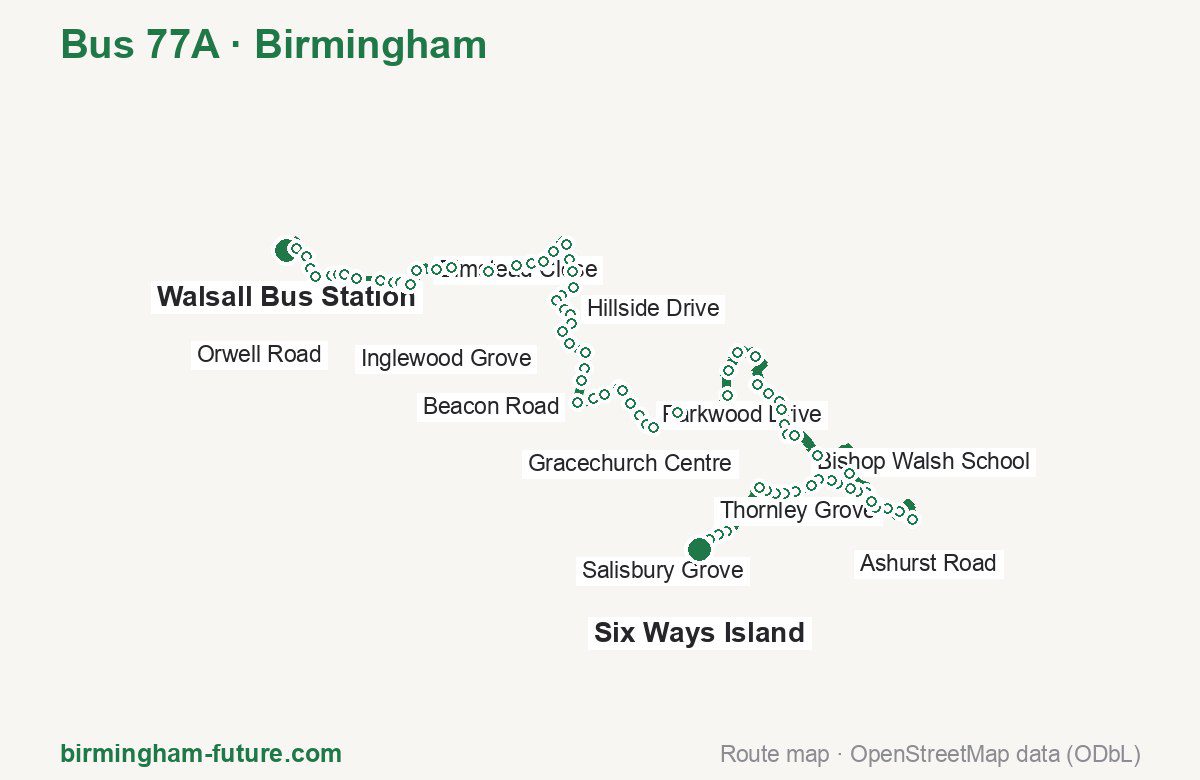
Route at a glance
| Mode | Bus |
|---|---|
| Route number | 77A |
| City | Birmingham |
| Operator | National Express West Midlands |
| Start → end | Walsall Bus Station → Six Ways Island |
| End → start | Six Ways Island → Walsall Bus Station |
| Route length | 33.6 km / 34.7 km in the opposite direction |
| Number of stops | 84 / 84 in the opposite direction |
| Travel time | about 91 minutes |
| Trips per day | 7 on weekdays one way |
| Frequency | peak 60–70 · midday 60 |
| First / last trip from «Walsall Bus Station» | 08:15 / 14:25 |
| First / last trip from «Six Ways Island» | 08:08 / 15:03 |
| Fare | 3.00 £ (fare in effect since 28 June 2026) |
| Updated | August 22, 2026 |
Route of Bus 77A
Outbound: Walsall Bus Station → Six Ways Island
This direction has 84 stops and runs 33.6 km. The route passes Walsall Town Hall, Inglewood Grove, Greenway Drive, Forge Croft. Below is the full list with the distance from the first stop.
| No. | Stop | From start | Note |
|---|---|---|---|
| 1 | Walsall Bus Station | 0.0 km | Terminus |
| 2 | Walsall Town Hall | 0.6 km | |
| 3 | Upper Rushall Street | 1.0 km | |
| 4 | Pool Street | 1.3 km | |
| 5 | Bernard Street | 1.5 km | |
| 6 | Lumley Road | 1.9 km | |
| 7 | Beaconsfield Court | 2.0 km | |
| 8 | Orwell Road | 2.2 km | |
| 9 | Broadway North | 2.5 km | |
| 10 | Greaves Avenue | 3.0 km | |
| 11 | Wood End Road | 3.4 km | |
| 12 | Appledore Road | 3.5 km | |
| 13 | Furze Way | 3.7 km | |
| 14 | Hay Hill | 3.8 km | |
| 15 | Elmstead Close | 4.2 km | |
| 16 | Skip Lane | 4.7 km | |
| 17 | Walsall Garden Centre | 5.0 km | |
| 18 | Barr Beacon Crossroads | 5.9 km | |
| 19 | Aldridge Road | 6.6 km | |
| 20 | Hazelwood Road | 6.9 km | |
| 21 | Schoolacre Rise | 7.2 km | |
| 22 | Inglewood Grove | 7.5 km | |
| 23 | Grange Drive | 8.0 km | |
| 24 | Foley Court | 8.4 km | |
| 25 | The Milestone | 8.7 km | |
| 26 | Beacon Court | 9.1 km | |
| 27 | Bridlewood | 9.4 km | |
| 28 | Bankside Crescent | 9.6 km | |
| 29 | Hillside Drive | 9.9 km | |
| 30 | Moss Way | 10.0 km | |
| 31 | Brabham Crescent | 10.3 km | |
| 32 | Lindens Primary School | 10.6 km | |
| 33 | The Queslett | 10.9 km | |
| 34 | Sutton Oak Corner | 11.4 km | |
| 35 | King George V Field | 11.8 km | |
| 36 | Beacon Road | 12.1 km | |
| 37 | Kingstanding Police Station | 12.6 km | |
| 38 | Winterton Road | 13.1 km | |
| 39 | Hollyhurst Road | 13.3 km | |
| 40 | Chester Road | 13.7 km | |
| 41 | Monmouth Drive | 13.8 km | |
| 42 | Greenway Drive | 14.2 km | |
| 43 | Parkwood Drive | 14.5 km | |
| 44 | Tesco | 14.8 km | |
| 45 | The Beggars Bush | 15.0 km | |
| 46 | Halton Road | 15.8 km | |
| 47 | Ashdene Close | 17.1 km | |
| 48 | Wyndley Lane | 17.8 km | |
| 49 | Fawdry Close | 18.2 km | |
| 50 | Gracechurch Centre | 19.4 km | |
| 51 | Shirley Drive | 20.3 km | |
| 52 | Douglas Road | 20.6 km | |
| 53 | Rowan Road | 20.9 km | |
| 54 | Shooters Hill | 21.1 km | |
| 55 | Recreation Ground | 21.4 km | |
| 56 | The Green | 21.7 km | |
| 57 | Bishop Walsh School | 21.9 km | |
| 58 | Allendale Road | 22.7 km | |
| 59 | Oak Farm Close | 24.2 km | |
| 60 | Walmley Ash Road | 24.8 km | |
| 61 | Walmley Ash Lane | 25.1 km | |
| 62 | Forge Croft | 25.3 km | |
| 63 | Asda Superstore | 25.6 km | |
| 64 | Thornley Grove | 26.1 km | |
| 65 | Arbury Walk | 27.0 km | |
| 66 | Asda Superstore | 25.6 km | |
| 67 | Forge Croft | 28.4 km | |
| 68 | Walmley Ash Lane | 28.6 km | |
| 69 | Walmley Junior School | 29.0 km | |
| 70 | Walmley Infant School | 29.2 km | |
| 71 | Ashurst Road | 29.5 km | |
| 72 | Ashfern Drive | 29.6 km | |
| 73 | Trident Close | 30.0 km | |
| 74 | Penns Lake Road | 30.2 km | |
| 75 | Penns Hall Hotel | 30.6 km | |
| 76 | The Chase | 30.8 km | |
| 77 | Berwood Road | 31.0 km | |
| 78 | Salisbury Grove | 31.3 km | |
| 79 | Beech Hill Road | 31.4 km | |
| 80 | Hart Road | 32.8 km | |
| 81 | Erdington Fire Station | 33.0 km | |
| 82 | New Street | 33.3 km | |
| 83 | Barnabas Road | 33.5 km | |
| 84 | Six Ways Island | 33.6 km | Terminus |
Inbound: Six Ways Island → Walsall Bus Station
This direction has 84 stops and runs 34.7 km. The route passes Barnabas Road, Walmley Ash Road, Parkwood Drive, Hardwick Road. Below is the full list with the distance from the first stop.
| No. | Stop | From start | Note |
|---|---|---|---|
| 1 | Six Ways Island | 0.0 km | Terminus |
| 2 | Barnabas Road | 0.1 km | |
| 3 | Wilton Road | 0.4 km | |
| 4 | Erdington Fire Station | 0.6 km | |
| 5 | Salisbury Grove | 2.3 km | |
| 6 | Fourlands Avenue | 2.5 km | |
| 7 | Berwood Road | 2.6 km | |
| 8 | The Chase | 2.8 km | |
| 9 | Penns Hall Hotel | 3.1 km | |
| 10 | Penns Lake Road | 3.5 km | |
| 11 | Ashfern Drive | 3.9 km | |
| 12 | Ashurst Road | 4.3 km | |
| 13 | Walmley Junior School | 4.5 km | |
| 14 | Walmley Ash Lane | 5.0 km | |
| 15 | Forge Croft | 5.3 km | |
| 16 | Asda Superstore | 5.5 km | |
| 17 | Thornley Grove | 6.1 km | |
| 18 | Arbury Walk | 7.0 km | |
| 19 | Asda Superstore | 5.5 km | |
| 20 | Forge Croft | 8.4 km | |
| 21 | Walmley Ash Lane | 8.6 km | |
| 22 | Walmley Ash Road | 8.8 km | |
| 23 | Oak Farm Close | 9.5 km | |
| 24 | Walmley Road | 10.9 km | |
| 25 | Allendale Road | 11.0 km | |
| 26 | The Green | 12.0 km | |
| 27 | Recreation Ground | 12.2 km | |
| 28 | Shooters Hill | 12.6 km | |
| 29 | Rowan Road | 12.8 km | |
| 30 | Douglas Road | 13.0 km | |
| 31 | Shirley Drive | 13.4 km | |
| 32 | Lower Queen Street | 13.7 km | |
| 33 | Trinity Hill | 14.4 km | |
| 34 | Trinity Church | 14.6 km | |
| 35 | Gracechurch Centre | 14.8 km | |
| 36 | Fawdry Close | 16.1 km | |
| 37 | Wyndley Lane | 16.6 km | |
| 38 | Ashdene Close | 17.2 km | |
| 39 | Halton Road | 18.6 km | |
| 40 | The Beggars Bush | 20.0 km | |
| 41 | Tesco | 20.2 km | |
| 42 | Parkwood Drive | 20.6 km | |
| 43 | Greenway Drive | 20.8 km | |
| 44 | Chester Road | 21.3 km | |
| 45 | Hollyhurst Road | 21.6 km | |
| 46 | Winterton Road | 21.9 km | |
| 47 | Kingstanding Police Station | 22.5 km | |
| 48 | Beacon Road | 22.9 km | |
| 49 | King George V Field | 23.4 km | |
| 50 | Sutton Oak Corner | 23.7 km | |
| 51 | The Queslett | 24.2 km | |
| 52 | Lindens Primary School | 24.6 km | |
| 53 | Brabham Crescent | 24.8 km | |
| 54 | Moss Way | 25.1 km | |
| 55 | Hillside Drive | 25.3 km | |
| 56 | Bankside Crescent | 25.5 km | |
| 57 | Blackwood Drive | 25.7 km | |
| 58 | Bridlewood | 25.9 km | |
| 59 | Manor Road | 26.2 km | |
| 60 | The Milestone | 26.5 km | |
| 61 | Foley Court | 26.9 km | |
| 62 | Hardwick Road | 27.2 km | |
| 63 | Inglewood Grove | 27.6 km | |
| 64 | Schoolacre Rise | 28.0 km | |
| 65 | Hazelwood Road | 28.2 km | |
| 66 | Foley Arms | 28.7 km | |
| 67 | Barr Beacon Crossroads | 29.2 km | |
| 68 | Walsall Garden Centre | 30.1 km | |
| 69 | Skip Lane | 30.5 km | |
| 70 | Elmstead Close | 31.0 km | |
| 71 | Corn Hill | 31.1 km | |
| 72 | Hay Hill | 31.3 km | |
| 73 | Furze Way | 31.4 km | |
| 74 | Appledore Road | 31.5 km | |
| 75 | Wood End Road | 31.8 km | |
| 76 | Greaves Avenue | 32.2 km | |
| 77 | Broadway North | 32.6 km | |
| 78 | Beaconsfield Court | 33.0 km | |
| 79 | Lumley Road | 33.2 km | |
| 80 | Bernard Street | 33.5 km | |
| 81 | Six Ways Walsall | 33.7 km | |
| 82 | Hill Street | 34.0 km | |
| 83 | Upper Bridge Street | 34.4 km | |
| 84 | Walsall Bus Station | 34.7 km | Terminus |
Schedule and frequency
According to the official schedule from National Express West Midlands, the route runs 7 trips in one direction on a weekday.
| Direction | Weekdays | Weekends and holidays |
|---|---|---|
| From «Walsall Bus Station» | 08:15 — 14:25 | — — — |
| From «Six Ways Island» | 08:08 — 15:03 | — — — |
Frequency calculated from the departure table: in the morning peak buses run every 60–70 minutes, most often every 65; midday every 60 minutes.
Fare and payment
A single ride costs 3.00 £ — fare in effect since 28 June 2026. The same fare applies to National Express buses in Birmingham.
A single journey on a National Express bus costs £3.00 and is valid on one bus for one journey only — it gives no transfer. A multi-operator nBus day ticket costs £5.50 and works on every operator in the scheme.
Frequently asked questions
How much does a ride on bus 77A cost?
3.00 £ for a single ride — fare in effect since 28 June 2026.
When do the first and last trips run?
From Walsall Bus Station the first is at 08:15 and the last at 14:25. From Six Ways Island they are 08:08 and 15:03.
How long does the trip from Walsall Bus Station to Six Ways Island take?
About 91 minutes end to end — the median of full trips in the official schedule.
How many stops does the route have?
84 outbound and 84 inbound according to the official GTFS feed. The two lists do not match exactly.
Does bus 77A run on weekends?
Yes, the route runs every day, with a separate weekend schedule.
Every route number with its termini, operating hours and travel time is collected in the Birmingham buses overview.
Data current as of August 22, 2026. Schedule and termini — National Express West Midlands. Fares — National Express West Midlands. Stop list, schedule and route geometry come from the official GTFS feed (Bus Open Data Service (BODS)).