

Bus 45 in Birmingham links Carrs Lane and Longbridge Island. The route is 17.5 km long with 55 stops, and the official schedule from National Express West Midlands puts the full trip at about 55 minutes. On a weekday it runs 95 trips in one direction, and 68 on a weekend day.
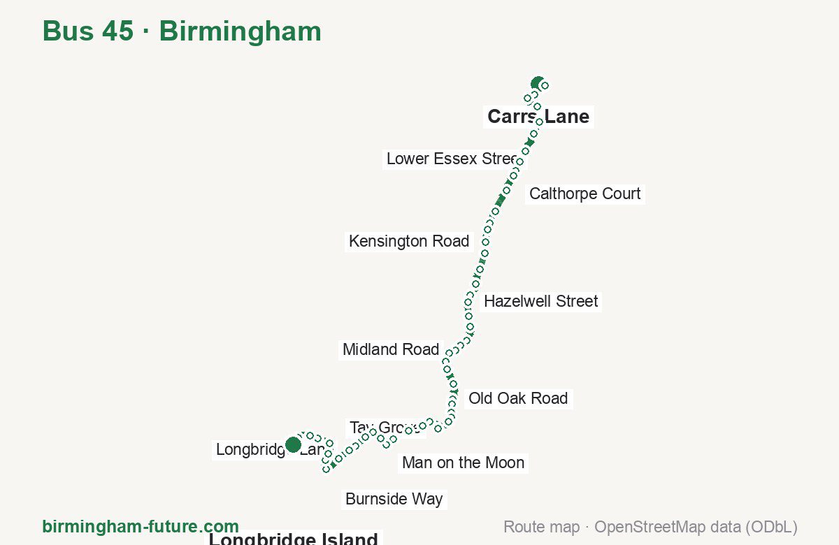
Route at a glance
| Mode | Bus |
|---|---|
| Route number | 45 |
| City | Birmingham |
| Operator | National Express West Midlands |
| Start → end | Carrs Lane → Longbridge Island |
| End → start | Longbridge Island → Carrs Lane |
| Route length | 17.5 km / 16.9 km in the opposite direction |
| Number of stops | 55 / 54 in the opposite direction |
| Travel time | about 55 minutes |
| Trips per day | 95 on weekdays, 68 on weekends one way (100 on weekdays → Carrs Lane) |
| Frequency | peak 3–15 · midday 3–15 · weekend 2–35 |
| First / last trip from «Carrs Lane» | 00:03 / 23:33 |
| First / last trip from «Longbridge Island» | 04:17 / 23:40 |
| Fare | 3.00 £ (fare in effect since 28 June 2026) |
| Updated | August 22, 2026 |
Route of Bus 45
Outbound: Carrs Lane → Longbridge Island
This direction has 55 stops and runs 17.5 km. The route passes Bus Mall, First Avenue, Kings Norton Station, Man on the Moon. Below is the full list with the distance from the first stop.
| No. | Stop | From start | Note |
|---|---|---|---|
| 1 | Carrs Lane | 0.0 km | Terminus |
| 2 | Bus Mall | 0.3 km | |
| 3 | New Street Station | 0.7 km | |
| 4 | Old Repertory Theatre | 1.1 km | |
| 5 | Bromsgrove Street | 1.5 km | |
| 6 | Lower Essex Street | 2.0 km | |
| 7 | Mowbray Street | 2.3 km | |
| 8 | Bellevue | 2.9 km | |
| 9 | Speedwell Road | 3.2 km | |
| 10 | Edward Road | 3.4 km | |
| 11 | Calthorpe Court | 3.6 km | |
| 12 | Priory Road | 4.0 km | |
| 13 | Nature Centre | 4.6 km | |
| 14 | Upland Road | 5.0 km | |
| 15 | First Avenue | 5.2 km | |
| 16 | Kensington Road | 5.5 km | |
| 17 | Kitchener Road | 5.8 km | |
| 18 | Dogpool Lane | 6.2 km | |
| 19 | Warwards Lane | 6.6 km | |
| 20 | Umberslade Road | 7.0 km | |
| 21 | Hazelwell Street | 7.2 km | |
| 22 | Elm Tree Road | 7.5 km | |
| 23 | Fordhouse Lane | 7.8 km | |
| 24 | Breedon Cross Bridge | 8.2 km | |
| 25 | Breedon Road | 8.4 km | |
| 26 | Midland Road | 8.6 km | |
| 27 | Watford Road | 8.8 km | |
| 28 | Kings Norton Station | 9.1 km | |
| 29 | Melchett Road | 9.3 km | |
| 30 | The Green | 9.7 km | |
| 31 | Old Oak Road | 10.1 km | |
| 32 | Lanchester Road | 10.3 km | |
| 33 | Cadbury College | 10.5 km | |
| 34 | Warrens End | 10.7 km | |
| 35 | Meadowsweet Avenue | 10.8 km | |
| 36 | Tay Grove | 11.2 km | |
| 37 | Aldi | 11.7 km | |
| 38 | Burford Park Road | 12.0 km | |
| 39 | Green Acres Road | 12.4 km | |
| 40 | Glendene Crescent | 12.9 km | |
| 41 | Man on the Moon | 13.2 km | |
| 42 | Sir Hiltons Road | 13.4 km | |
| 43 | The Grove | 13.7 km | |
| 44 | St John Fisher Church | 14.0 km | |
| 45 | Dormy Drive | 14.6 km | |
| 46 | Longbridge Lane | 14.8 km | |
| 47 | Kingswood Walk | 15.1 km | |
| 48 | Edenhurst Road | 15.6 km | |
| 49 | Thurlestone Road | 15.8 km | |
| 50 | Grayswood Road | 16.1 km | |
| 51 | Burnside Way | 16.4 km | |
| 52 | Longbridge Station | 16.7 km | |
| 53 | Devon Way | 16.9 km | |
| 54 | South and City College | 17.3 km | |
| 55 | Longbridge Island | 17.5 km | Terminus |
Inbound: Longbridge Island → Carrs Lane
This direction has 54 stops and runs 16.9 km. The route passes Devon Way, Green Acres Road, Kings Norton Station, First Avenue. Below is the full list with the distance from the first stop.
| No. | Stop | From start | Note |
|---|---|---|---|
| 1 | Longbridge Island | 0.0 km | Terminus |
| 2 | Devon Way | 0.6 km | |
| 3 | Longbridge Station | 0.8 km | |
| 4 | Grayswood Road | 1.4 km | |
| 5 | Thurlestone Road | 1.8 km | |
| 6 | Edenhurst Road | 2.0 km | |
| 7 | Kingswood Walk | 2.5 km | |
| 8 | Longbridge Lane | 2.8 km | |
| 9 | Dormy Drive | 3.1 km | |
| 10 | St John Fisher Church | 3.4 km | |
| 11 | Rednal Road | 3.7 km | |
| 12 | Sir Hiltons Road | 3.9 km | |
| 13 | Redhill Road | 4.2 km | |
| 14 | Glendene Crescent | 4.4 km | |
| 15 | Green Acres Road | 4.8 km | |
| 16 | Burford Park Road | 5.2 km | |
| 17 | Teviot Grove | 5.7 km | |
| 18 | Medway Grove | 6.0 km | |
| 19 | Tay Grove | 6.3 km | |
| 20 | Meadowsweet Avenue | 6.6 km | |
| 21 | Warrens End | 6.8 km | |
| 22 | Cadbury College | 6.9 km | |
| 23 | Lanchester Road | 7.2 km | |
| 24 | Old Oak Road | 7.3 km | |
| 25 | The Green | 7.7 km | |
| 26 | Melchett Road | 8.2 km | |
| 27 | Camp Lane | 8.3 km | |
| 28 | Kings Norton Station | 8.4 km | |
| 29 | Cotteridge Island | 8.6 km | |
| 30 | Midland Road | 8.9 km | |
| 31 | Breedon Road | 9.1 km | |
| 32 | Breedon Cross Bridge | 9.3 km | |
| 33 | Fordhouse Lane | 9.6 km | |
| 34 | Elm Tree Road | 9.9 km | |
| 35 | Bournville Lane | 10.3 km | |
| 36 | Umberslade Road | 10.5 km | |
| 37 | Warwards Lane | 11.0 km | |
| 38 | Dogpool Lane | 11.4 km | |
| 39 | Kitchener Road | 11.8 km | |
| 40 | Kensington Road | 12.0 km | |
| 41 | First Avenue | 12.3 km | |
| 42 | Upland Road | 12.6 km | |
| 43 | Nature Centre | 12.9 km | |
| 44 | South Drive | 13.3 km | |
| 45 | Priory Road | 13.7 km | |
| 46 | Calthorpe Court | 13.8 km | |
| 47 | Edward Road | 14.2 km | |
| 48 | Speedwell Road | 14.5 km | |
| 49 | Bellevue | 14.8 km | |
| 50 | Mowbray Street | 15.2 km | |
| 51 | Lower Essex Street | 15.6 km | |
| 52 | Bromsgrove Street | 16.0 km | |
| 53 | Markets | 16.3 km | |
| 54 | Carrs Lane | 16.9 km | Terminus |
Schedule and frequency
According to the official schedule from National Express West Midlands, the route runs 95 trips in one direction on a weekday, and 68 on a weekend day.
| Direction | Weekdays | Weekends and holidays |
|---|---|---|
| From «Carrs Lane» | 00:03 — 23:33 | 00:03 — 23:33 |
| From «Longbridge Island» | 04:17 — 23:40 | 06:17 — 23:45 |
Frequency calculated from the departure table: in the morning peak buses run every 3–15 minutes, most often every 10; midday every 3–15 minutes; in the afternoon peak every 3–20; on weekends every 2–35 minutes.
Fare and payment
A single ride costs 3.00 £ — fare in effect since 28 June 2026. The same fare applies to National Express buses in Birmingham.
A single journey on a National Express bus costs £3.00 and is valid on one bus for one journey only — it gives no transfer. A multi-operator nBus day ticket costs £5.50 and works on every operator in the scheme.
Frequently asked questions
How much does a ride on bus 45 cost?
3.00 £ for a single ride — fare in effect since 28 June 2026.
When do the first and last trips run?
From Carrs Lane the first is at 00:03 and the last at 23:33. From Longbridge Island they are 04:17 and 23:40.
How long does the trip from Carrs Lane to Longbridge Island take?
About 55 minutes end to end — the median of full trips in the official schedule.
How many stops does the route have?
55 outbound and 54 inbound according to the official GTFS feed. The two lists do not match exactly.
Does bus 45 run on weekends?
Yes. On weekends and holidays there are 68 trips in one direction, running from Carrs Lane between 00:03 and 23:33.
Every route number with its termini, operating hours and travel time is collected in the Birmingham buses overview.
Data current as of August 22, 2026. Schedule and termini — National Express West Midlands. Fares — National Express West Midlands. Stop list, schedule and route geometry come from the official GTFS feed (Bus Open Data Service (BODS)).