

Bus X12 in Birmingham links Dale End and Solihull Station. The route is 40.8 km long with 74 stops, and the official schedule from National Express West Midlands puts the full trip at about 92 minutes. On a weekday it runs 38 trips in one direction, and 32 on a weekend day.
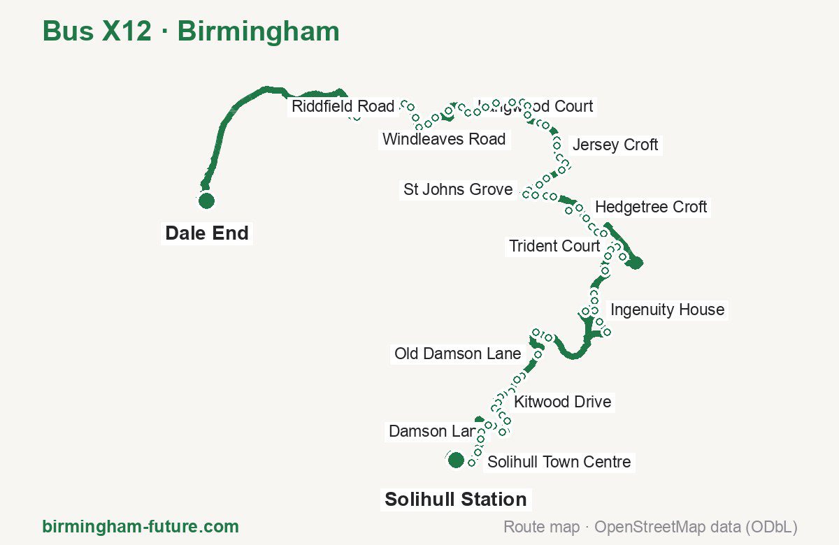
Route at a glance
| Mode | Bus |
|---|---|
| Route number | X12 |
| City | Birmingham |
| Operator | National Express West Midlands |
| Start → end | Dale End → Solihull Station |
| End → start | Solihull Station → Dale End |
| Route length | 40.8 km / 36.4 km in the opposite direction |
| Number of stops | 74 / 76 in the opposite direction |
| Travel time | about 92 minutes |
| Trips per day | 38 on weekdays, 32 on weekends one way (41 on weekdays → Dale End) |
| Frequency | peak 30 · midday 30 · weekend 30–60 |
| First / last trip from «Dale End» | 04:18 / 23:20 |
| First / last trip from «Solihull Station» | 05:00 / 23:43 |
| Fare | 3.00 £ (fare in effect since 28 June 2026) |
| Updated | August 22, 2026 |
Route of Bus X12
Outbound: Dale End → Solihull Station
This direction has 74 stops and runs 40.8 km. The route passes Bromford Way, Tamar Drive, Carisbrooke Avenue, Land Rover Works. Below is the full list with the distance from the first stop.
| No. | Stop | From start | Note |
|---|---|---|---|
| 1 | Dale End | 0.0 km | Terminus |
| 2 | Bromford Way | 7.6 km | |
| 3 | Reynoldstown Road | 7.9 km | |
| 4 | Sundew Croft | 8.4 km | |
| 5 | Sandown Road | 8.8 km | |
| 6 | Folkestone Croft | 9.1 km | |
| 7 | Riddfield Road | 9.3 km | |
| 8 | Millington Road | 9.7 km | |
| 9 | Shawsdale Road | 10.0 km | |
| 10 | Clock Garage | 10.3 km | |
| 11 | Heathland Avenue | 10.6 km | |
| 12 | Southfield Avenue | 11.3 km | |
| 13 | Langwood Court | 11.8 km | |
| 14 | Poplars Drive | 12.0 km | |
| 15 | Whateley Green | 12.3 km | |
| 16 | Arden Hall | 12.6 km | |
| 17 | West Avenue | 12.9 km | |
| 18 | Clevedon Avenue | 13.4 km | |
| 19 | Windleaves Road | 13.7 km | |
| 20 | Tamar Drive | 13.9 km | |
| 21 | Trent Drive | 14.1 km | |
| 22 | Mey Coppice | 14.7 km | |
| 23 | Woodpecker Grove | 14.8 km | |
| 24 | Smiths Wood Academy | 15.4 km | |
| 25 | Jersey Croft | 15.6 km | |
| 26 | Woodlands Green | 15.9 km | |
| 27 | Bacons End Island | 16.2 km | |
| 28 | Tower Croft | 16.5 km | |
| 29 | Corinne Croft | 17.0 km | |
| 30 | Tudor Grange Academy | 17.3 km | |
| 31 | St Johns Grove | 17.6 km | |
| 32 | Craneberry Road | 17.9 km | |
| 33 | John Henry Newman College | 18.1 km | |
| 34 | Blackcat Close | 18.5 km | |
| 35 | Conway Road | 18.7 km | |
| 36 | Chelmsley Interchange | 19.8 km | |
| 37 | Hedgetree Croft | 20.5 km | |
| 38 | Carisbrooke Avenue | 20.8 km | |
| 39 | Dunster Road | 21.1 km | |
| 40 | Barnard Close | 21.3 km | |
| 41 | Chester Road | 21.6 km | |
| 42 | Knights Court | 24.0 km | |
| 43 | Trident Court | 24.4 km | |
| 44 | Lakeside | 24.6 km | |
| 45 | Waterside Centre | 24.9 km | |
| 46 | Blackfirs Lane | 25.4 km | |
| 47 | Elmdon Trading Estate | 26.2 km | |
| 48 | Morris Way | 26.4 km | |
| 49 | Ingenuity House | 26.7 km | |
| 50 | Birmingham International Station | 27.3 km | |
| 51 | Trinity Park | 27.7 km | |
| 52 | Birmingham Airport Bus Terminal | 29.2 km | |
| 53 | Falcon Way | 32.1 km | |
| 54 | Cargo Terminal | 32.5 km | |
| 55 | Old Damson Lane | 33.4 km | |
| 56 | Land Rover Works | 34.2 km | |
| 57 | Whar Hall Road | 34.3 km | |
| 58 | Dalecote Avenue | 34.7 km | |
| 59 | Eastfield Drive | 35.0 km | |
| 60 | Stockwell Rise | 35.2 km | |
| 61 | Kitwood Drive | 35.4 km | |
| 62 | Rowood Drive | 35.6 km | |
| 63 | Mitford Drive | 35.8 km | |
| 64 | Walsgrave Close | 36.0 km | |
| 65 | Lugtrout Lane | 36.2 km | |
| 66 | Heath Road | 36.5 km | |
| 67 | Damson Lane | 36.7 km | |
| 68 | Alston Road | 37.0 km | |
| 69 | Moat Lane | 37.2 km | |
| 70 | Redlands Road | 37.8 km | |
| 71 | Grove Road | 39.1 km | |
| 72 | Solihull Hospital | 39.5 km | |
| 73 | Solihull Town Centre | 39.8 km | |
| 74 | Solihull Station | 40.8 km | Terminus |
Inbound: Solihull Station → Dale End
This direction has 76 stops and runs 36.4 km. The route passes Solihull Town Centre, Falcon Way, Conway Road, Clevedon Avenue. Below is the full list with the distance from the first stop.
| No. | Stop | From start | Note |
|---|---|---|---|
| 1 | Solihull Station | 0.0 km | Terminus |
| 2 | Solihull Town Centre | 0.5 km | |
| 3 | Solihull Hospital | 1.0 km | |
| 4 | Grove Road | 1.2 km | |
| 5 | Hermitage Road | 1.5 km | |
| 6 | Alston Road | 2.3 km | |
| 7 | Damson Lane | 2.7 km | |
| 8 | Heath Road | 2.8 km | |
| 9 | Lugtrout Lane | 3.0 km | |
| 10 | Walsgrave Close | 3.3 km | |
| 11 | Mitford Drive | 3.5 km | |
| 12 | Rowood Drive | 3.7 km | |
| 13 | Kitwood Drive | 4.0 km | |
| 14 | Stockwell Rise | 4.2 km | |
| 15 | Eastfield Drive | 4.3 km | |
| 16 | Dalecote Avenue | 4.6 km | |
| 17 | Land Rover Works | 5.1 km | |
| 18 | Old Damson Lane | 6.0 km | |
| 19 | Cargo Terminal | 6.8 km | |
| 20 | Falcon Way | 7.2 km | |
| 21 | Airport Way | 9.0 km | |
| 22 | Birmingham Airport Bus Terminal | 9.9 km | |
| 23 | Birmingham International Station | 10.5 km | |
| 24 | Trinity Park | 10.9 km | |
| 25 | Morris Way | 12.3 km | |
| 26 | Elmdon Trading Estate | 12.6 km | |
| 27 | Blackfirs Lane | 13.4 km | |
| 28 | Waterside Centre | 13.8 km | |
| 29 | Lakeside | 14.0 km | |
| 30 | Trident Court | 14.3 km | |
| 31 | Knights Court | 14.6 km | |
| 32 | Chester Road | 16.4 km | |
| 33 | Barnard Close | 16.6 km | |
| 34 | Dunster Road | 16.9 km | |
| 35 | Carisbrooke Avenue | 17.1 km | |
| 36 | Hedgetree Croft | 17.6 km | |
| 37 | Chelmsley Interchange | 18.4 km | |
| 38 | Conway Road | 19.0 km | |
| 39 | Blackcat Close | 19.4 km | |
| 40 | John Henry Newman College | 19.7 km | |
| 41 | Craneberry Road | 19.9 km | |
| 42 | St Johns Grove | 20.1 km | |
| 43 | Hillside Drive | 20.3 km | |
| 44 | Tudor Grange Academy | 20.5 km | |
| 45 | Corinne Croft | 20.9 km | |
| 46 | Tower Croft | 21.4 km | |
| 47 | Bacons End Island | 21.6 km | |
| 48 | Woodlands Green | 21.9 km | |
| 49 | Jersey Croft | 22.2 km | |
| 50 | Smiths Wood Academy | 22.4 km | |
| 51 | Woodpecker Grove | 22.9 km | |
| 52 | Mey Coppice | 23.2 km | |
| 53 | Trent Drive | 23.7 km | |
| 54 | Tamar Drive | 23.9 km | |
| 55 | Windleaves Road | 24.2 km | |
| 56 | Clevedon Avenue | 24.4 km | |
| 57 | West Avenue | 24.9 km | |
| 58 | Arden Hall | 25.2 km | |
| 59 | Whateley Green | 25.5 km | |
| 60 | Cedar Avenue | 25.6 km | |
| 61 | Poplars Drive | 25.8 km | |
| 62 | Southfield Avenue | 26.5 km | |
| 63 | Heathland Avenue | 27.1 km | |
| 64 | Clock Garage | 27.5 km | |
| 65 | Heath Way | 27.7 km | |
| 66 | Shawsdale Road | 27.8 km | |
| 67 | Millington Road | 28.1 km | |
| 68 | Kempson Road | 28.4 km | |
| 69 | Riddfield Road | 28.4 km | |
| 70 | Folkestone Croft | 28.7 km | |
| 71 | Sandown Road | 28.9 km | |
| 72 | Sundew Croft | 29.3 km | |
| 73 | Reynoldstown Road | 29.9 km | |
| 74 | Bromford Way | 30.2 km | |
| 75 | The Bromford | 30.5 km | |
| 76 | Dale End | 36.4 km | Terminus |
Schedule and frequency
According to the official schedule from National Express West Midlands, the route runs 38 trips in one direction on a weekday, and 32 on a weekend day.
| Direction | Weekdays | Weekends and holidays |
|---|---|---|
| From «Dale End» | 04:18 — 23:20 | 04:18 — 23:20 |
| From «Solihull Station» | 05:00 — 23:43 | 05:25 — 23:43 |
Frequency calculated from the departure table: in the morning peak buses run every 30 minutes; midday every 30 minutes; in the afternoon peak every 25–35; on weekends every 30–60 minutes.
Fare and payment
A single ride costs 3.00 £ — fare in effect since 28 June 2026. The same fare applies to National Express buses in Birmingham.
A single journey on a National Express bus costs £3.00 and is valid on one bus for one journey only — it gives no transfer. A multi-operator nBus day ticket costs £5.50 and works on every operator in the scheme.
Frequently asked questions
How much does a ride on bus X12 cost?
3.00 £ for a single ride — fare in effect since 28 June 2026.
When do the first and last trips run?
From Dale End the first is at 04:18 and the last at 23:20. From Solihull Station they are 05:00 and 23:43.
How long does the trip from Dale End to Solihull Station take?
About 92 minutes end to end — the median of full trips in the official schedule.
How many stops does the route have?
74 outbound and 76 inbound according to the official GTFS feed. The two lists do not match exactly.
Does bus X12 run on weekends?
Yes. On weekends and holidays there are 32 trips in one direction, running from Dale End between 04:18 and 23:20.
Every route number with its termini, operating hours and travel time is collected in the Birmingham buses overview.
Data current as of August 22, 2026. Schedule and termini — National Express West Midlands. Fares — National Express West Midlands. Stop list, schedule and route geometry come from the official GTFS feed (Bus Open Data Service (BODS)).