

Bus 4A in Birmingham links Church Centre and Solihull Town Centre. The route is 17.9 km long with 56 stops, and the official schedule from National Express West Midlands puts the full trip at about 58 minutes. On a weekday it runs 51 trips in one direction, and 34 on a weekend day.
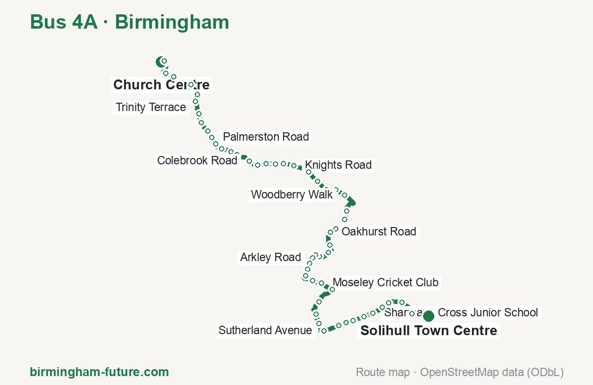
Route at a glance
| Mode | Bus |
|---|---|
| Route number | 4A |
| City | Birmingham |
| Operator | National Express West Midlands |
| Start → end | Church Centre → Solihull Town Centre |
| End → start | Solihull Town Centre → Church Centre |
| Route length | 17.9 km / 17.1 km in the opposite direction |
| Number of stops | 56 / 57 in the opposite direction |
| Travel time | about 58 minutes |
| Trips per day | 51 on weekdays, 34 on weekends one way |
| Frequency | peak 20 · midday 20 · weekend 30–35 |
| First / last trip from «Church Centre» | 00:00 / 23:30 |
| First / last trip from «Solihull Town Centre» | 04:24 / 23:09 |
| Fare | 3.00 £ (fare in effect since 28 June 2026) |
| Updated | August 22, 2026 |
Route of Bus 4A
Outbound: Church Centre → Solihull Town Centre
This direction has 56 stops and runs 17.9 km. The route passes Bus Mall, St Johns Road, Pollard Road, Moseley Cricket Club. Below is the full list with the distance from the first stop.
| No. | Stop | From start | Note |
|---|---|---|---|
| 1 | Church Centre | 0.0 km | Terminus |
| 2 | Bus Mall | 0.4 km | |
| 3 | Allison Street | 0.9 km | |
| 4 | Birmingham Coach Station | 1.1 km | |
| 5 | Adderley Street | 1.7 km | |
| 6 | Trinity Terrace | 2.0 km | |
| 7 | Ravenhurst Street | 2.2 km | |
| 8 | Auckland Road | 2.6 km | |
| 9 | Main Street | 2.9 km | |
| 10 | Ludlow Court | 3.2 km | |
| 11 | Palmerston Road | 3.4 km | |
| 12 | Poplar Road | 3.6 km | |
| 13 | Oriel Villas | 3.9 km | |
| 14 | Shakespeare Street | 4.1 km | |
| 15 | St Johns Road | 4.3 km | |
| 16 | Colebrook Road | 4.8 km | |
| 17 | Manor Farm Road | 5.0 km | |
| 18 | Boscombe Road | 5.3 km | |
| 19 | Medina Road | 5.5 km | |
| 20 | Tyseley Railway Museum | 5.8 km | |
| 21 | Knights Road | 6.1 km | |
| 22 | Fox Hollies Road | 6.5 km | |
| 23 | Merstowe Close | 6.9 km | |
| 24 | Primary School | 7.3 km | |
| 25 | Station Road | 7.5 km | |
| 26 | Woodberry Walk | 7.8 km | |
| 27 | Thornfield Road | 8.5 km | |
| 28 | Pollard Road | 8.8 km | |
| 29 | Fox Hollies Park | 9.0 km | |
| 30 | Severne Grove | 9.3 km | |
| 31 | Oakhurst Road | 9.5 km | |
| 32 | Nailstone Crescent | 9.9 km | |
| 33 | Tavistock Road | 10.2 km | |
| 34 | St Michael’s Church | 10.5 km | |
| 35 | Mapleton Road | 10.7 km | |
| 36 | Arkley Road | 10.8 km | |
| 37 | Sleaford Road | 11.0 km | |
| 38 | Robin Hood Academy | 11.1 km | |
| 39 | Hazelville Road | 11.3 km | |
| 40 | Chadwell Drive | 11.7 km | |
| 41 | Moseley Cricket Club | 11.9 km | |
| 42 | Robin Hood Cemetery | 12.3 km | |
| 43 | Pailton Road | 12.9 km | |
| 44 | Jacey Road | 13.3 km | |
| 45 | Saracens Head | 13.6 km | |
| 46 | Sutherland Avenue | 13.9 km | |
| 47 | Thornyfield Road | 14.4 km | |
| 48 | Stanway Road | 14.6 km | |
| 49 | Ashwell Drive | 14.8 km | |
| 50 | Prospect Lane | 15.2 km | |
| 51 | Sharmans Cross Junior School | 15.4 km | |
| 52 | Woodside Way | 15.8 km | |
| 53 | Streetsbrook Road | 16.0 km | |
| 54 | Broadoaks | 16.4 km | |
| 55 | Solihull Station | 16.9 km | |
| 56 | Solihull Town Centre | 17.9 km | Terminus |
Inbound: Solihull Town Centre → Church Centre
This direction has 57 stops and runs 17.1 km. The route passes Solihull Station, Moseley Cricket Club, Pollard Road, Medina Road. Below is the full list with the distance from the first stop.
| No. | Stop | From start | Note |
|---|---|---|---|
| 1 | Solihull Town Centre | 0.0 km | Terminus |
| 2 | Solihull Station | 0.6 km | |
| 3 | Broadoaks | 0.9 km | |
| 4 | Streetsbrook Road | 1.4 km | |
| 5 | Woodside Way | 1.7 km | |
| 6 | Sharmans Cross Junior School | 2.0 km | |
| 7 | Ashwell Drive | 2.4 km | |
| 8 | Stanway Road | 2.6 km | |
| 9 | Thornyfield Road | 3.1 km | |
| 10 | Sutherland Avenue | 3.5 km | |
| 11 | Saracens Head | 3.7 km | |
| 12 | Jacey Road | 4.1 km | |
| 13 | Pailton Road | 4.5 km | |
| 14 | Robin Hood Cemetery | 5.1 km | |
| 15 | Moseley Cricket Club | 5.5 km | |
| 16 | Chadwell Drive | 5.7 km | |
| 17 | Hazelville Road | 6.1 km | |
| 18 | Robin Hood Academy | 6.3 km | |
| 19 | Sleaford Road | 6.5 km | |
| 20 | Arkley Road | 6.7 km | |
| 21 | Mapleton Road | 6.8 km | |
| 22 | Gospel Farm Road | 7.0 km | |
| 23 | Tavistock Road | 7.2 km | |
| 24 | Nailstone Crescent | 7.5 km | |
| 25 | Oakhurst Road | 7.9 km | |
| 26 | Severne Grove | 8.1 km | |
| 27 | Dorsington Road | 8.3 km | |
| 28 | Pollard Road | 8.6 km | |
| 29 | Thornfield Road | 8.8 km | |
| 30 | Bretton Road | 9.1 km | |
| 31 | Culham Close | 9.3 km | |
| 32 | Woodberry Walk | 9.5 km | |
| 33 | Station Road | 9.8 km | |
| 34 | Acocks Green Village | 10.0 km | |
| 35 | Primary School | 10.2 km | |
| 36 | Merstowe Close | 10.6 km | |
| 37 | Fox Hollies Road | 10.8 km | |
| 38 | Tyseley Lane | 11.2 km | |
| 39 | Knights Road | 11.4 km | |
| 40 | Tyseley Railway Museum | 11.8 km | |
| 41 | Medina Road | 12.0 km | |
| 42 | Boscombe Road | 12.2 km | |
| 43 | Manor Farm Road | 12.5 km | |
| 44 | Colebrook Road | 12.7 km | |
| 45 | St Johns Road | 13.1 km | |
| 46 | Shakespeare Street | 13.3 km | |
| 47 | Oriel Villas | 13.6 km | |
| 48 | Poplar Road | 13.8 km | |
| 49 | Palmerston Road | 14.0 km | |
| 50 | Ludlow Court | 14.3 km | |
| 51 | Main Street | 14.5 km | |
| 52 | Auckland Road | 14.8 km | |
| 53 | Ravenhurst Street | 15.2 km | |
| 54 | Adderley Street | 15.8 km | |
| 55 | Birmingham Coach Station | 16.3 km | |
| 56 | Park Street | 16.7 km | |
| 57 | Church Centre | 17.1 km | Terminus |
Schedule and frequency
According to the official schedule from National Express West Midlands, the route runs 51 trips in one direction on a weekday, and 34 on a weekend day.
| Direction | Weekdays | Weekends and holidays |
|---|---|---|
| From «Church Centre» | 00:00 — 23:30 | 00:00 — 23:30 |
| From «Solihull Town Centre» | 04:24 — 23:09 | 06:23 — 23:09 |
Frequency calculated from the departure table: in the morning peak buses run every 20 minutes; midday every 20 minutes; in the afternoon peak every 15–22; on weekends every 30–35 minutes.
Fare and payment
A single ride costs 3.00 £ — fare in effect since 28 June 2026. The same fare applies to National Express buses in Birmingham.
A single journey on a National Express bus costs £3.00 and is valid on one bus for one journey only — it gives no transfer. A multi-operator nBus day ticket costs £5.50 and works on every operator in the scheme.
Frequently asked questions
How much does a ride on bus 4A cost?
3.00 £ for a single ride — fare in effect since 28 June 2026.
When do the first and last trips run?
From Church Centre the first is at 00:00 and the last at 23:30. From Solihull Town Centre they are 04:24 and 23:09.
How long does the trip from Church Centre to Solihull Town Centre take?
About 58 minutes end to end — the median of full trips in the official schedule.
How many stops does the route have?
56 outbound and 57 inbound according to the official GTFS feed. The two lists do not match exactly.
Does bus 4A run on weekends?
Yes. On weekends and holidays there are 34 trips in one direction, running from Church Centre between 00:00 and 23:30.
Every route number with its termini, operating hours and travel time is collected in the Birmingham buses overview.
Data current as of August 22, 2026. Schedule and termini — National Express West Midlands. Fares — National Express West Midlands. Stop list, schedule and route geometry come from the official GTFS feed (Bus Open Data Service (BODS)).