

Bus 41 in Birmingham links Queen Elizabeth Hospital and Buckland End Shops. The route is 24.3 km long with 82 stops, and the official schedule from National Express West Midlands puts the full trip at about 80 minutes. On a weekday it runs 40 trips in one direction.
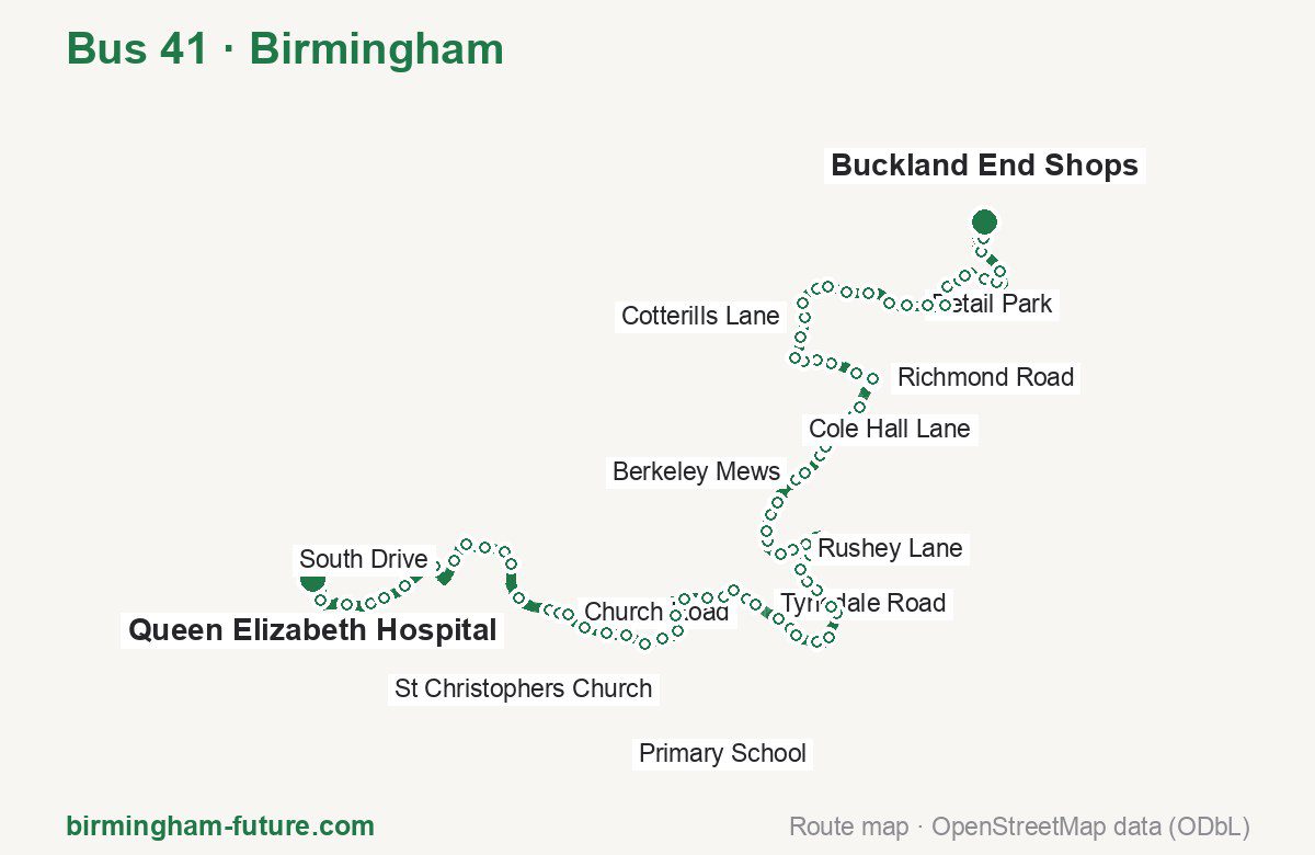
Route at a glance
| Mode | Bus |
|---|---|
| Route number | 41 |
| City | Birmingham |
| Operator | National Express West Midlands |
| Start → end | Queen Elizabeth Hospital → Buckland End Shops |
| End → start | Buckland End Shops → Queen Elizabeth Hospital |
| Route length | 24.3 km / 24.5 km in the opposite direction |
| Number of stops | 82 / 79 in the opposite direction |
| Travel time | about 80 minutes |
| Trips per day | 40 on weekdays one way |
| Frequency | peak 5–30 · midday 5–30 |
| First / last trip from «Queen Elizabeth Hospital» | 06:25 / 20:10 |
| First / last trip from «Buckland End Shops» | 06:15 / 19:40 |
| Fare | 3.00 £ (fare in effect since 28 June 2026) |
| Updated | August 22, 2026 |
Route of Bus 41
Outbound: Queen Elizabeth Hospital → Buckland End Shops
This direction has 82 stops and runs 24.3 km. The route passes The Oleaster, St Christophers Church, Wharf Road, Bordesley Green. Below is the full list with the distance from the first stop.
| No. | Stop | From start | Note |
|---|---|---|---|
| 1 | Queen Elizabeth Hospital | 0.0 km | Terminus |
| 2 | The Oleaster | 0.4 km | |
| 3 | Grange Road | 0.9 km | |
| 4 | Bournbrook Road | 1.3 km | |
| 5 | Edgbaston Park Road | 1.5 km | |
| 6 | Eastern Road | 1.9 km | |
| 7 | Bristol Road | 2.5 km | |
| 8 | South Drive | 3.0 km | |
| 9 | Warwickshire Cricket Ground | 3.4 km | |
| 10 | Midlands Arts Centre | 3.7 km | |
| 11 | Cannon Hill Park | 4.0 km | |
| 12 | Park Hill | 4.2 km | |
| 13 | Amesbury Road | 4.7 km | |
| 14 | Moseley Village | 5.3 km | |
| 15 | Church Road | 5.4 km | |
| 16 | Lench’s Close | 5.6 km | |
| 17 | Mayfield Court | 5.9 km | |
| 18 | Billesley Lane | 6.2 km | |
| 19 | Mackenzie Road | 6.5 km | |
| 20 | Wake Green Road | 6.9 km | |
| 21 | Moseley Sec School | 7.2 km | |
| 22 | St Christophers Church | 7.5 km | |
| 23 | Greswolde Road | 7.7 km | |
| 24 | Pentos Drive | 8.1 km | |
| 25 | Leominster Road | 8.5 km | |
| 26 | Tetley Road | 8.7 km | |
| 27 | Electricity Works | 8.9 km | |
| 28 | Matlock Road | 9.2 km | |
| 29 | Tynedale Road | 9.3 km | |
| 30 | Briarfield Road | 9.7 km | |
| 31 | LIDL | 10.0 km | |
| 32 | Fox Hollies Road | 10.1 km | |
| 33 | Northanger Road | 10.5 km | |
| 34 | Cearl Court | 10.7 km | |
| 35 | Public Library | 11.1 km | |
| 36 | Primary School | 11.2 km | |
| 37 | Merstowe Close | 11.6 km | |
| 38 | Fox Hollies Road | 11.8 km | |
| 39 | Stockfield Road | 12.0 km | |
| 40 | Douglas Road | 12.3 km | |
| 41 | Kilmorie Road | 12.6 km | |
| 42 | Wharf Road | 13.0 km | |
| 43 | Rushey Lane | 13.2 km | |
| 44 | Blythswood Road | 13.4 km | |
| 45 | Hay Hall Road | 13.7 km | |
| 46 | Redfern Road | 13.9 km | |
| 47 | James Road | 14.1 km | |
| 48 | Speedwell Road | 14.3 km | |
| 49 | Berkeley Road | 14.9 km | |
| 50 | Berkeley Mews | 15.0 km | |
| 51 | Fast Pits Road | 15.4 km | |
| 52 | Hob Moor Road | 15.5 km | |
| 53 | Bierton Road | 15.9 km | |
| 54 | Kestrel Avenue | 16.1 km | |
| 55 | Blakesley Road | 16.3 km | |
| 56 | Bordesley Green East | 16.8 km | |
| 57 | Richmond Road | 16.8 km | |
| 58 | Upton Road | 17.1 km | |
| 59 | Eastfield Road | 17.5 km | |
| 60 | Kenwood Road | 17.7 km | |
| 61 | Heartlands Hospital | 17.9 km | |
| 62 | Bordesley Green | 18.2 km | |
| 63 | Saltley Grammar School | 18.5 km | |
| 64 | Cotterills Lane | 18.8 km | |
| 65 | Pelham Road | 19.0 km | |
| 66 | Bankdale Road | 19.4 km | |
| 67 | Treaford Lane | 19.5 km | |
| 68 | Washwood Heath Academy | 19.8 km | |
| 69 | Cotterills Lane | 20.1 km | |
| 70 | Station Road | 20.5 km | |
| 71 | Retail Park | 20.8 km | |
| 72 | Harrowfield Road | 21.1 km | |
| 73 | Lyme Green Road | 21.4 km | |
| 74 | Wheatstone Grove | 21.7 km | |
| 75 | Lathom Grove | 21.9 km | |
| 76 | Bushbury Road | 22.1 km | |
| 77 | Greswold Gardens | 22.5 km | |
| 78 | Cole Hall Lane | 22.7 km | |
| 79 | Watland Green | 23.0 km | |
| 80 | Rivermead Park | 23.4 km | |
| 81 | Cole Hall Lane | 23.7 km | |
| 82 | Buckland End Shops | 24.3 km | Terminus |
Inbound: Buckland End Shops → Queen Elizabeth Hospital
This direction has 79 stops and runs 24.5 km. The route passes Rivermead Park, Bordesley Green, Wharf Road, St Christophers Church. Below is the full list with the distance from the first stop.
| No. | Stop | From start | Note |
|---|---|---|---|
| 1 | Buckland End Shops | 0.0 km | Terminus |
| 2 | Rivermead Park | 0.7 km | |
| 3 | Watland Green | 1.1 km | |
| 4 | Middle Leaford | 1.2 km | |
| 5 | Cole Hall Lane | 1.4 km | |
| 6 | Greswold Gardens | 1.6 km | |
| 7 | Bushbury Road | 2.0 km | |
| 8 | Lathom Grove | 2.1 km | |
| 9 | Wheatstone Grove | 2.4 km | |
| 10 | Penkridge Grove | 2.6 km | |
| 11 | Harrowfield Road | 3.0 km | |
| 12 | Retail Park | 3.3 km | |
| 13 | Manor Farm Drive | 3.7 km | |
| 14 | Cotterills Lane | 4.0 km | |
| 15 | Washwood Heath Academy | 4.3 km | |
| 16 | Treaford Lane | 4.7 km | |
| 17 | Bankdale Road | 4.9 km | |
| 18 | Alum Rock Road | 5.2 km | |
| 19 | Cotterills Lane | 5.4 km | |
| 20 | Saltley Grammar School | 5.6 km | |
| 21 | Bordesley Green | 5.9 km | |
| 22 | Heartlands Hospital | 6.1 km | |
| 23 | Kenwood Road | 6.3 km | |
| 24 | Eastfield Road | 6.7 km | |
| 25 | Upton Road | 7.0 km | |
| 26 | Bordesley Green East | 7.3 km | |
| 27 | Blakesley Road | 7.7 km | |
| 28 | Kestrel Avenue | 7.9 km | |
| 29 | Bierton Road | 8.1 km | |
| 30 | Hob Moor Road | 8.5 km | |
| 31 | Fast Pits Road | 8.7 km | |
| 32 | Berkeley Mews | 9.1 km | |
| 33 | Coventry Road | 9.3 km | |
| 34 | Coventry Road | 9.5 km | |
| 35 | James Road | 9.9 km | |
| 36 | Redfern Road | 10.3 km | |
| 37 | Tyseley Station | 10.5 km | |
| 38 | Blythswood Road | 10.7 km | |
| 39 | Rushey Lane | 10.9 km | |
| 40 | Wharf Road | 11.2 km | |
| 41 | Kilmorie Road | 11.6 km | |
| 42 | Douglas Road | 11.9 km | |
| 43 | Fox Hollies Road | 12.3 km | |
| 44 | Merstowe Close | 12.7 km | |
| 45 | Acocks Green Village | 13.1 km | |
| 46 | Cearl Court | 13.5 km | |
| 47 | Grayland Close | 13.7 km | |
| 48 | Northanger Road | 13.9 km | |
| 49 | Fox Hollies Road | 14.1 km | |
| 50 | LIDL | 14.3 km | |
| 51 | Briarfield Road | 14.6 km | |
| 52 | Tynedale Road | 15.0 km | |
| 53 | Matlock Road | 15.1 km | |
| 54 | St Edmunds Church | 15.5 km | |
| 55 | Tetley Road | 15.7 km | |
| 56 | Leominster Road | 15.9 km | |
| 57 | Pentos Drive | 16.2 km | |
| 58 | Greswolde Road | 16.7 km | |
| 59 | St Christophers Church | 16.8 km | |
| 60 | Moseley Sec School | 17.2 km | |
| 61 | Mackenzie Road | 17.6 km | |
| 62 | Yardley Wood Road | 17.9 km | |
| 63 | Billesley Lane | 18.2 km | |
| 64 | Mayfield Court | 18.5 km | |
| 65 | Lench’s Close | 18.7 km | |
| 66 | Church Road | 18.9 km | |
| 67 | Moseley Village | 19.2 km | |
| 68 | Amesbury Road | 19.6 km | |
| 69 | Park Hill | 20.1 km | |
| 70 | Cannon Hill Park | 20.4 km | |
| 71 | Midlands Arts Centre | 20.7 km | |
| 72 | Priory Road | 21.1 km | |
| 73 | Pebble Mill Road | 22.0 km | |
| 74 | Eastern Road | 22.4 km | |
| 75 | Edgbaston Park Road | 22.8 km | |
| 76 | Bournbrook Road | 23.1 km | |
| 77 | Grange Road | 23.5 km | |
| 78 | The Oleaster | 24.0 km | |
| 79 | Queen Elizabeth Hospital | 24.5 km | Terminus |
Schedule and frequency
According to the official schedule from National Express West Midlands, the route runs 40 trips in one direction on a weekday.
| Direction | Weekdays | Weekends and holidays |
|---|---|---|
| From «Queen Elizabeth Hospital» | 06:25 — 20:10 | — — — |
| From «Buckland End Shops» | 06:15 — 19:40 | — — — |
Frequency calculated from the departure table: in the morning peak buses run every 5–30 minutes, most often every 25; midday every 5–30 minutes; in the afternoon peak every 30–60.
Fare and payment
A single ride costs 3.00 £ — fare in effect since 28 June 2026. The same fare applies to National Express buses in Birmingham.
A single journey on a National Express bus costs £3.00 and is valid on one bus for one journey only — it gives no transfer. A multi-operator nBus day ticket costs £5.50 and works on every operator in the scheme.
Frequently asked questions
How much does a ride on bus 41 cost?
3.00 £ for a single ride — fare in effect since 28 June 2026.
When do the first and last trips run?
From Queen Elizabeth Hospital the first is at 06:25 and the last at 20:10. From Buckland End Shops they are 06:15 and 19:40.
How long does the trip from Queen Elizabeth Hospital to Buckland End Shops take?
About 80 minutes end to end — the median of full trips in the official schedule.
How many stops does the route have?
82 outbound and 79 inbound according to the official GTFS feed. The two lists do not match exactly.
Does bus 41 run on weekends?
Yes, the route runs every day, with a separate weekend schedule.
Every route number with its termini, operating hours and travel time is collected in the Birmingham buses overview.
Data current as of August 22, 2026. Schedule and termini — National Express West Midlands. Fares — National Express West Midlands. Stop list, schedule and route geometry come from the official GTFS feed (Bus Open Data Service (BODS)).