

Bus X21 in Birmingham links The Square Peg and Merry Hill Bus Station. The route is 29.3 km long with 79 stops, and the official schedule from National Express West Midlands puts the full trip at about 47 minutes. On a weekday it runs 51 trips in one direction, and 36 on a weekend day.
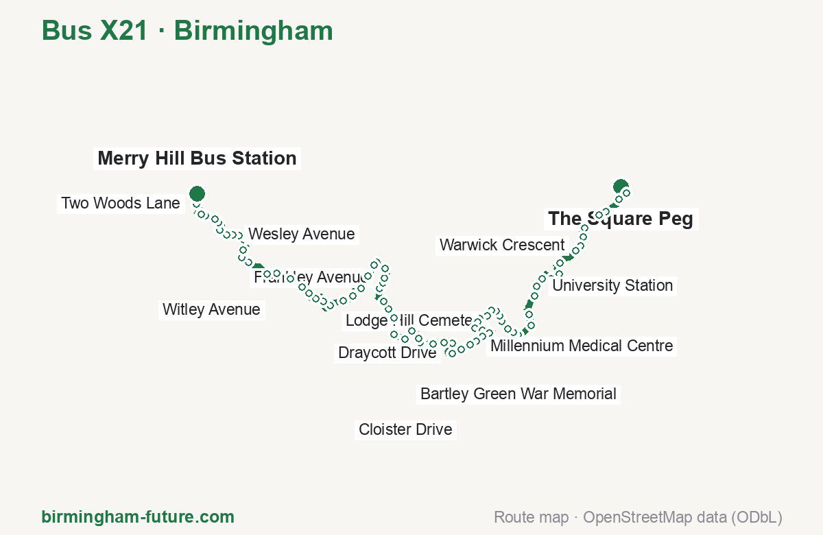
Route at a glance
| Mode | Bus |
|---|---|
| Route number | X21 |
| City | Birmingham |
| Operator | National Express West Midlands |
| Start → end | The Square Peg → Merry Hill Bus Station |
| End → start | Merry Hill Bus Station → The Square Peg |
| Route length | 29.3 km / 29.3 km in the opposite direction |
| Number of stops | 79 / 83 in the opposite direction |
| Travel time | about 47 minutes |
| Trips per day | 51 on weekdays, 36 on weekends one way |
| Frequency | peak 20 · midday 20 · weekend 30 |
| First / last trip from «The Square Peg» | 00:10 / 23:40 |
| First / last trip from «Merry Hill Bus Station» | 05:05 / 23:55 |
| Fare | 3.00 £ (fare in effect since 28 June 2026) |
| Updated | August 22, 2026 |
Route of Bus X21
Outbound: The Square Peg → Merry Hill Bus Station
This direction has 79 stops and runs 29.3 km. The route passes Bus Mall, Springdale Gardens, Brett Drive, Woodman Close. Below is the full list with the distance from the first stop.
| No. | Stop | From start | Note |
|---|---|---|---|
| 1 | The Square Peg | 0.0 km | Terminus |
| 2 | Bus Mall | 0.4 km | |
| 3 | New Street Station | 0.8 km | |
| 4 | Ernest Street | 1.4 km | |
| 5 | Granville Street | 1.7 km | |
| 6 | Edencroft | 2.5 km | |
| 7 | Gilldown Place | 2.8 km | |
| 8 | Warwick Crescent | 3.1 km | |
| 9 | Aston House | 3.4 km | |
| 10 | Vale Village | 4.1 km | |
| 11 | Westmere | 4.5 km | |
| 12 | School of Education | 4.9 km | |
| 13 | University North Gate | 5.1 km | |
| 14 | Blood & Transplant Centre | 5.6 km | |
| 15 | University Station | 5.9 km | |
| 16 | The Oleaster | 6.3 km | |
| 17 | Gibbins Road | 7.0 km | |
| 18 | Lodge Hill Road | 7.5 km | |
| 19 | Hamilton Drive | 8.1 km | |
| 20 | Westhill Close | 8.3 km | |
| 21 | Springdale Gardens | 8.5 km | |
| 22 | Lodge Hill Cemetery | 8.8 km | |
| 23 | Woolacombe Lodge Road | 9.1 km | |
| 24 | Corisande Road | 9.3 km | |
| 25 | Kemberton Road | 9.5 km | |
| 26 | Kemberton Road Middle | 9.8 km | |
| 27 | Jervoise Road | 10.1 km | |
| 28 | Barcheston Road | 10.2 km | |
| 29 | Millennium Medical Centre | 10.5 km | |
| 30 | Princethorpe Road | 10.7 km | |
| 31 | Castlecroft | 11.3 km | |
| 32 | Ruckley Road | 11.6 km | |
| 33 | Quarry Road | 11.8 km | |
| 34 | Marston Road | 12.1 km | |
| 35 | Shenley Academy | 12.4 km | |
| 36 | Draycott Drive | 12.8 km | |
| 37 | Shenley Fields Centre | 13.4 km | |
| 38 | Bartley Drive | 13.8 km | |
| 39 | Monmouth Road | 14.2 km | |
| 40 | Brett Drive | 14.7 km | |
| 41 | Culford Drive | 14.8 km | |
| 42 | Bartley Green School | 15.2 km | |
| 43 | Bartley Green War Memorial | 15.6 km | |
| 44 | Burrington Road | 16.0 km | |
| 45 | Lye Avenue | 16.6 km | |
| 46 | The Old Crown | 17.0 km | |
| 47 | Gleads Croft | 17.3 km | |
| 48 | Carters Lane Church | 17.9 km | |
| 49 | Lydate Road | 18.2 km | |
| 50 | Frankley Avenue | 18.3 km | |
| 51 | Howley Grange School | 18.7 km | |
| 52 | Goodrest Avenue | 19.0 km | |
| 53 | Shenstone Valley Road | 19.2 km | |
| 54 | Shenstone Avenue | 19.7 km | |
| 55 | Priory Road | 20.2 km | |
| 56 | Lapal Lane North | 20.7 km | |
| 57 | Cloister Drive | 21.1 km | |
| 58 | Manor Abbey Stadium | 21.6 km | |
| 59 | Woodman Close | 22.0 km | |
| 60 | Pool Road | 22.4 km | |
| 61 | Halesowen Bus Station | 22.8 km | |
| 62 | Windsor Road | 23.2 km | |
| 63 | Alexandra Road | 23.8 km | |
| 64 | Witley Avenue | 24.3 km | |
| 65 | Belle Vale | 24.6 km | |
| 66 | Foredraft Street | 25.4 km | |
| 67 | Mapletree Lane | 25.7 km | |
| 68 | Cradley Library | 26.0 km | |
| 69 | Littlehill Crescent | 26.4 km | |
| 70 | Middletree Road | 26.6 km | |
| 71 | Wesley Avenue | 26.9 km | |
| 72 | Blaenwern Drive | 27.1 km | |
| 73 | The Forge | 27.4 km | |
| 74 | Woodland Avenue | 27.7 km | |
| 75 | Quarry Bank School | 27.9 km | |
| 76 | Chapel Street | 28.3 km | |
| 77 | Sun Street | 28.4 km | |
| 78 | Two Woods Lane | 28.9 km | |
| 79 | Merry Hill Bus Station | 29.3 km | Terminus |
Inbound: Merry Hill Bus Station → The Square Peg
This direction has 83 stops and runs 29.3 km. The route passes Two Woods Lane, Manor Abbey Stadium, Monmouth Road, Lodge Hill Cemetery Gates. Below is the full list with the distance from the first stop.
| No. | Stop | From start | Note |
|---|---|---|---|
| 1 | Merry Hill Bus Station | 0.0 km | Terminus |
| 2 | Two Woods Lane | 0.4 km | |
| 3 | Sun Street | 1.0 km | |
| 4 | Chapel Street | 1.2 km | |
| 5 | Quarry Bank School | 1.5 km | |
| 6 | Woodland Avenue | 1.6 km | |
| 7 | The Forge | 1.9 km | |
| 8 | Blaenwern Drive | 2.2 km | |
| 9 | Wesley Avenue | 2.4 km | |
| 10 | Middletree Road | 2.7 km | |
| 11 | Littlehill Crescent | 3.0 km | |
| 12 | Cradley Library | 3.4 km | |
| 13 | Mapletree Lane | 3.7 km | |
| 14 | Foredraft Street | 4.0 km | |
| 15 | Belle Vale | 4.8 km | |
| 16 | Witley Avenue | 5.0 km | |
| 17 | Alexandra Road | 5.4 km | |
| 18 | Windsor Road | 6.1 km | |
| 19 | Halesowen Bus Station | 6.5 km | |
| 20 | Pool Road | 6.9 km | |
| 21 | Woodman Close | 7.4 km | |
| 22 | Manor Abbey Stadium | 7.8 km | |
| 23 | Cloister Drive | 8.2 km | |
| 24 | Lapal Lane North | 8.9 km | |
| 25 | Priory Road | 9.1 km | |
| 26 | Shenstone Avenue | 9.7 km | |
| 27 | Shenstone Valley Road | 10.1 km | |
| 28 | Goodrest Avenue | 10.3 km | |
| 29 | Howley Grange School | 10.6 km | |
| 30 | Seven Acres Road | 10.8 km | |
| 31 | Lydate Road | 11.2 km | |
| 32 | Manor Way Bridge | 11.5 km | |
| 33 | Gleads Croft | 11.9 km | |
| 34 | The Old Crown | 12.3 km | |
| 35 | Lye Avenue | 12.6 km | |
| 36 | Kempsey House | 13.2 km | |
| 37 | Bartley Green War Memorial | 13.7 km | |
| 38 | Bartley Green School | 14.0 km | |
| 39 | Culford Drive | 14.4 km | |
| 40 | Brett Drive | 14.6 km | |
| 41 | Newman University | 14.8 km | |
| 42 | Monmouth Road | 15.1 km | |
| 43 | Bartley Drive | 15.5 km | |
| 44 | Shenley Fields Centre | 15.8 km | |
| 45 | Longfield Road | 16.2 km | |
| 46 | Draycott Drive | 16.4 km | |
| 47 | Shenley Academy | 16.7 km | |
| 48 | Fulbrook Grove | 16.9 km | |
| 49 | Marston Road | 17.2 km | |
| 50 | Quarry Road | 17.5 km | |
| 51 | Ruckley Road | 17.7 km | |
| 52 | Gregory Avenue | 17.9 km | |
| 53 | Princethorpe Road | 18.1 km | |
| 54 | Weoley Castle Post Office | 18.3 km | |
| 55 | Weoley Castle Library | 18.6 km | |
| 56 | Barcheston Road | 18.9 km | |
| 57 | Jervoise Road | 19.0 km | |
| 58 | Kemberton Road Middle | 19.3 km | |
| 59 | Alwold Road | 19.5 km | |
| 60 | Corisande Road | 19.9 km | |
| 61 | Woolacombe Lodge Road | 20.1 km | |
| 62 | Lodge Hill Cemetery Gates | 20.4 km | |
| 63 | Westhill Close | 20.8 km | |
| 64 | College Walk | 21.1 km | |
| 65 | Rebecca Drive | 21.7 km | |
| 66 | Gibbins Road | 22.0 km | |
| 67 | The Oleaster | 22.7 km | |
| 68 | University Station | 23.1 km | |
| 69 | Blood & Transplant Centre | 23.4 km | |
| 70 | University North Gate | 24.0 km | |
| 71 | Westmere | 24.5 km | |
| 72 | Vale Village | 25.0 km | |
| 73 | Aston House | 25.6 km | |
| 74 | Warwick Crescent | 25.9 km | |
| 75 | Gilldown Place | 26.2 km | |
| 76 | George Road | 26.6 km | |
| 77 | Five Ways Station | 27.1 km | |
| 78 | Granville Street | 27.5 km | |
| 79 | Ernest Street | 27.8 km | |
| 80 | Smallbrook Queensway | 28.2 km | |
| 81 | New Street Station | 28.4 km | |
| 82 | Albert Street | 28.9 km | |
| 83 | The Square Peg | 29.3 km | Terminus |
Schedule and frequency
According to the official schedule from National Express West Midlands, the route runs 51 trips in one direction on a weekday, and 36 on a weekend day.
| Direction | Weekdays | Weekends and holidays |
|---|---|---|
| From «The Square Peg» | 00:10 — 23:40 | 00:10 — 23:40 |
| From «Merry Hill Bus Station» | 05:05 — 23:55 | 06:26 — 23:55 |
Frequency calculated from the departure table: in the morning peak buses run every 20 minutes; midday every 20 minutes; in the afternoon peak every 20–30; on weekends every 30 minutes.
Fare and payment
A single ride costs 3.00 £ — fare in effect since 28 June 2026. The same fare applies to National Express buses in Birmingham.
A single journey on a National Express bus costs £3.00 and is valid on one bus for one journey only — it gives no transfer. A multi-operator nBus day ticket costs £5.50 and works on every operator in the scheme.
Frequently asked questions
How much does a ride on bus X21 cost?
3.00 £ for a single ride — fare in effect since 28 June 2026.
When do the first and last trips run?
From The Square Peg the first is at 00:10 and the last at 23:40. From Merry Hill Bus Station they are 05:05 and 23:55.
How long does the trip from The Square Peg to Merry Hill Bus Station take?
About 47 minutes end to end — the median of full trips in the official schedule.
How many stops does the route have?
79 outbound and 83 inbound according to the official GTFS feed. The two lists do not match exactly.
Does bus X21 run on weekends?
Yes. On weekends and holidays there are 36 trips in one direction, running from The Square Peg between 00:10 and 23:40.
Every route number with its termini, operating hours and travel time is collected in the Birmingham buses overview.
Data current as of August 22, 2026. Schedule and termini — National Express West Midlands. Fares — National Express West Midlands. Stop list, schedule and route geometry come from the official GTFS feed (Bus Open Data Service (BODS)).