

Bus 937 in Birmingham links Old Square and Rising Sun Island. The route is 25.4 km long with 63 stops, and the official schedule from National Express West Midlands puts the full trip at about 62 minutes. On a weekday it runs 32 trips in one direction, and 16 on a weekend day.
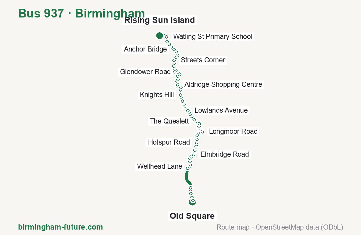
Route at a glance
| Mode | Bus |
|---|---|
| Route number | 937 |
| City | Birmingham |
| Operator | National Express West Midlands |
| Start → end | Old Square → Rising Sun Island |
| End → start | Rising Sun Island → Old Square |
| Route length | 25.4 km / 24.8 km in the opposite direction |
| Number of stops | 63 / 66 in the opposite direction |
| Travel time | about 62 minutes |
| Trips per day | 32 on weekdays, 16 on weekends one way |
| Frequency | peak 30 · midday 30 · weekend 55–67 |
| First / last trip from «Old Square» | 06:10 / 23:17 |
| First / last trip from «Rising Sun Island» | 05:25 / 22:23 |
| Fare | 3.00 £ (fare in effect since 28 June 2026) |
| Updated | August 22, 2026 |
Route of Bus 937
Outbound: Old Square → Rising Sun Island
This direction has 63 stops and runs 25.4 km. The route passes Ryder Street, Rushden Croft, Beacon Hill, Jessie Road. Below is the full list with the distance from the first stop.
| No. | Stop | From start | Note |
|---|---|---|---|
| 1 | Old Square | 0.0 km | Terminus |
| 2 | Ryder Street | 0.4 km | |
| 3 | Lower Tower Street | 1.3 km | |
| 4 | Milton Street | 2.0 km | |
| 5 | Perry Barr Rail Station | 4.4 km | |
| 6 | Wellhead Lane | 4.8 km | |
| 7 | Holford Drive | 5.1 km | |
| 8 | Nash Square | 5.4 km | |
| 9 | Perry Park | 5.8 km | |
| 10 | Aldridge Road | 6.1 km | |
| 11 | Elmbridge Road | 6.5 km | |
| 12 | Crossway Lane | 6.8 km | |
| 13 | Greenholm Road | 7.0 km | |
| 14 | Melverley Grove | 7.4 km | |
| 15 | Dyas Road | 7.7 km | |
| 16 | Hotspur Road | 8.0 km | |
| 17 | Rushden Croft | 8.3 km | |
| 18 | Harringay Road | 8.6 km | |
| 19 | Kingstanding Library | 8.8 km | |
| 20 | Winterton Road | 9.4 km | |
| 21 | Longmoor Road | 9.7 km | |
| 22 | Sutton Park Primary School | 10.0 km | |
| 23 | Westwood Road | 10.3 km | |
| 24 | King George V Field | 10.5 km | |
| 25 | Sutton Oak Corner | 10.8 km | |
| 26 | The Queslett | 11.4 km | |
| 27 | Hundred Acre Road | 11.6 km | |
| 28 | Farmer Johns | 12.1 km | |
| 29 | Old Lindens Close | 12.4 km | |
| 30 | Barr Common Farm | 12.7 km | |
| 31 | Lowlands Avenue | 12.9 km | |
| 32 | Beacon Hill | 13.6 km | |
| 33 | Bronstone Stables | 13.8 km | |
| 34 | Little Hardwick Road | 14.1 km | |
| 35 | Valley Nurseries | 14.2 km | |
| 36 | Knights Hill | 15.0 km | |
| 37 | St Francis College | 15.6 km | |
| 38 | Hallcroft Way | 15.9 km | |
| 39 | Rookery Lane | 16.2 km | |
| 40 | The Avion | 16.5 km | |
| 41 | Aldridge Shopping Centre | 16.6 km | |
| 42 | Greenfields | 17.1 km | |
| 43 | Leighswood School | 17.5 km | |
| 44 | Wellfield Road | 17.9 km | |
| 45 | Lazy Hill Road | 18.3 km | |
| 46 | Glendower Road | 18.7 km | |
| 47 | Jessie Road | 19.0 km | |
| 48 | Herbert Road | 19.2 km | |
| 49 | Castle Road | 19.8 km | |
| 50 | Laburnum Road | 20.2 km | |
| 51 | Streets Corner | 20.5 km | |
| 52 | Shire Oak Hill | 21.0 km | |
| 53 | Shire Oak Close | 21.4 km | |
| 54 | Adams Road | 21.6 km | |
| 55 | Friezland Lane | 21.9 km | |
| 56 | Anchor Bridge | 22.2 km | |
| 57 | Warren Place | 22.7 km | |
| 58 | Brickiln Street | 22.9 km | |
| 59 | Raven’s Court | 23.1 km | |
| 60 | Holland Park | 23.5 km | |
| 61 | Watling St Primary School | 24.1 km | |
| 62 | Hednesford Road | 24.9 km | |
| 63 | Rising Sun Island | 25.4 km | Terminus |
Inbound: Rising Sun Island → Old Square
This direction has 66 stops and runs 24.8 km. The route passes Hednesford Road, Jessie Road, Little Hardwick Road, Harringay Road. Below is the full list with the distance from the first stop.
| No. | Stop | From start | Note |
|---|---|---|---|
| 1 | Rising Sun Island | 0.0 km | Terminus |
| 2 | Hednesford Road | 0.3 km | |
| 3 | Watling St Primary School | 0.9 km | |
| 4 | The Park View Centre | 1.6 km | |
| 5 | Raven’s Court | 1.8 km | |
| 6 | Brickiln Street | 2.0 km | |
| 7 | Silver Street | 2.2 km | |
| 8 | Warren Place | 2.5 km | |
| 9 | Anchor Bridge | 2.8 km | |
| 10 | Friezland Lane | 3.1 km | |
| 11 | Adams Road | 3.4 km | |
| 12 | Shire Oak Close | 3.6 km | |
| 13 | Shire Oak Hill | 4.0 km | |
| 14 | Streets Corner | 4.4 km | |
| 15 | Laburnum Road | 4.8 km | |
| 16 | Sunnyside | 5.2 km | |
| 17 | Longleat Road | 5.7 km | |
| 18 | Jessie Road | 6.0 km | |
| 19 | Walton Road | 6.1 km | |
| 20 | Glendower Road | 6.3 km | |
| 21 | Lazy Hill Road | 6.6 km | |
| 22 | Norfolk Crescent | 6.8 km | |
| 23 | Wellfield Road | 7.1 km | |
| 24 | Leighswood School | 7.5 km | |
| 25 | Greenfields | 7.8 km | |
| 26 | Aldridge Post Office | 8.1 km | |
| 27 | Aldridge Shopping Centre | 8.4 km | |
| 28 | The Avion | 8.5 km | |
| 29 | Rookery Lane | 8.8 km | |
| 30 | Hallcroft Way | 9.1 km | |
| 31 | St Francis College | 9.4 km | |
| 32 | Knights Hill | 10.0 km | |
| 33 | Valley Nurseries | 10.7 km | |
| 34 | Little Hardwick Road | 10.9 km | |
| 35 | Bronstone Stables | 11.2 km | |
| 36 | The Foley Arms | 11.5 km | |
| 37 | Lowlands Avenue | 12.1 km | |
| 38 | Barr Common Farm | 12.3 km | |
| 39 | Old Lindens Close | 12.7 km | |
| 40 | Farmer Johns | 12.9 km | |
| 41 | Hundred Acre Road | 13.3 km | |
| 42 | The Queslett | 13.7 km | |
| 43 | Sutton Oak Corner | 14.1 km | |
| 44 | King George V Field | 14.5 km | |
| 45 | Westwood Road | 14.7 km | |
| 46 | Sutton Park Primary School | 14.9 km | |
| 47 | Longmoor Road | 15.3 km | |
| 48 | Winterton Road | 15.5 km | |
| 49 | Kingstanding Circle | 16.0 km | |
| 50 | Harringay Road | 16.3 km | |
| 51 | Rushden Croft | 16.7 km | |
| 52 | Hotspur Road | 17.0 km | |
| 53 | Westward Close | 17.4 km | |
| 54 | Melverley Grove | 17.6 km | |
| 55 | Greenholm Road | 17.8 km | |
| 56 | Crossway Lane | 18.1 km | |
| 57 | Elmbridge Road | 18.4 km | |
| 58 | Perry Park | 19.1 km | |
| 59 | Nash Square | 19.5 km | |
| 60 | Holford Drive | 19.8 km | |
| 61 | Wellhead Lane | 20.2 km | |
| 62 | Bragg Road | 20.7 km | |
| 63 | Milton Street | 22.9 km | |
| 64 | Lower Tower Street | 23.5 km | |
| 65 | Dalton Street | 24.5 km | |
| 66 | Old Square | 24.8 km | Terminus |
Schedule and frequency
According to the official schedule from National Express West Midlands, the route runs 32 trips in one direction on a weekday, and 16 on a weekend day.
| Direction | Weekdays | Weekends and holidays |
|---|---|---|
| From «Old Square» | 06:10 — 23:17 | 08:15 — 23:17 |
| From «Rising Sun Island» | 05:25 — 22:23 | 07:35 — 22:23 |
Frequency calculated from the departure table: in the morning peak buses run every 30 minutes; midday every 30 minutes; in the afternoon peak every 30; on weekends every 55–67 minutes.
Fare and payment
A single ride costs 3.00 £ — fare in effect since 28 June 2026. The same fare applies to National Express buses in Birmingham.
A single journey on a National Express bus costs £3.00 and is valid on one bus for one journey only — it gives no transfer. A multi-operator nBus day ticket costs £5.50 and works on every operator in the scheme.
Frequently asked questions
How much does a ride on bus 937 cost?
3.00 £ for a single ride — fare in effect since 28 June 2026.
When do the first and last trips run?
From Old Square the first is at 06:10 and the last at 23:17. From Rising Sun Island they are 05:25 and 22:23.
How long does the trip from Old Square to Rising Sun Island take?
About 62 minutes end to end — the median of full trips in the official schedule.
How many stops does the route have?
63 outbound and 66 inbound according to the official GTFS feed. The two lists do not match exactly.
Does bus 937 run on weekends?
Yes. On weekends and holidays there are 16 trips in one direction, running from Old Square between 08:15 and 23:17.
Every route number with its termini, operating hours and travel time is collected in the Birmingham buses overview.
Data current as of August 22, 2026. Schedule and termini — National Express West Midlands. Fares — National Express West Midlands. Stop list, schedule and route geometry come from the official GTFS feed (Bus Open Data Service (BODS)).