

Bus 99 in Birmingham links Solihull Station and Kingshurst Way. The route is 0.0 km long with 67 stops, and the official schedule from National Express West Midlands puts the full trip at about 58 minutes. On a weekday it runs 15 trips in one direction, and 9 on a weekend day.
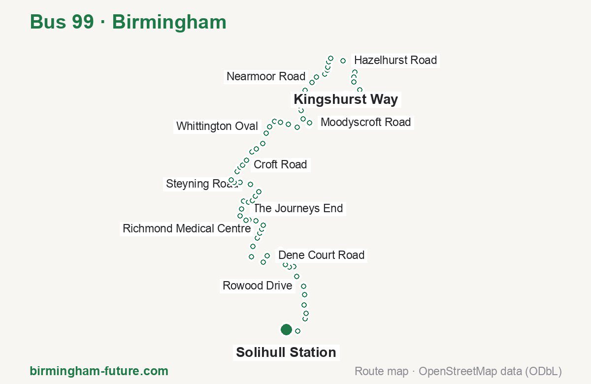
Route at a glance
| Mode | Bus |
|---|---|
| Route number | 99 |
| City | Birmingham |
| Operator | National Express West Midlands |
| Start → end | Solihull Station → Kingshurst Way |
| End → start | Kingshurst Way → Solihull Station |
| Route length | 0.0 km / 0.0 km in the opposite direction |
| Number of stops | 67 / 69 in the opposite direction |
| Travel time | about 58 minutes |
| Trips per day | 15 on weekdays, 9 on weekends one way |
| Frequency | peak 30–60 · midday 60–67 · weekend 60 |
| First / last trip from «Solihull Station» | 06:30 / 18:05 |
| First / last trip from «Kingshurst Way» | 07:05 / 18:35 |
| Fare | 3.00 £ (fare in effect since 28 June 2026) |
| Updated | August 22, 2026 |
Route of Bus 99
Outbound: Solihull Station → Kingshurst Way
This direction has 67 stops. The route passes Solihull Town Centre, Pierce Avenue, Swan Island, Yockleton Road. The full list of stops in order is below.
| No. | Stop | From start | Note |
|---|---|---|---|
| 1 | Solihull Station | 0.0 km | Terminus |
| 2 | Solihull Town Centre | 0.0 km | |
| 3 | Solihull Hospital | 0.0 km | |
| 4 | Grove Road | 0.0 km | |
| 5 | Hermitage Road | 0.0 km | |
| 6 | Lode Heath School | 0.0 km | |
| 7 | Rowood Drive | 0.0 km | |
| 8 | Henley Crescent | 0.0 km | |
| 9 | Dovecote Close | 0.0 km | |
| 10 | Dursley Close | 0.0 km | |
| 11 | Knights Bridge Road | 0.0 km | |
| 12 | Oakham Way | 0.0 km | |
| 13 | Dene Court Road | 0.0 km | |
| 14 | Chelmscote Road | 0.0 km | |
| 15 | Olton Station | 0.0 km | |
| 16 | Barrington Road | 0.0 km | |
| 17 | Fernhill Road | 0.0 km | |
| 18 | Pierce Avenue | 0.0 km | |
| 19 | Richmond Medical Centre | 0.0 km | |
| 20 | The Lyndon | 0.0 km | |
| 21 | Shalford Road | 0.0 km | |
| 22 | Bosworth Road | 0.0 km | |
| 23 | The Vineries | 0.0 km | |
| 24 | Cambridge Way | 0.0 km | |
| 25 | The Journeys End | 0.0 km | |
| 26 | Aldershaw Road | 0.0 km | |
| 27 | Measham Grove | 0.0 km | |
| 28 | Gilbertstone Avenue | 0.0 km | |
| 29 | Wichnor Road | 0.0 km | |
| 30 | Gotham Road | 0.0 km | |
| 31 | Steyning Road | 0.0 km | |
| 32 | Clay Lane | 0.0 km | |
| 33 | Swan Shopping Centre | 0.0 km | |
| 34 | Swan Island | 0.0 km | |
| 35 | Yardley Primary School | 0.0 km | |
| 36 | Yew Tree | 0.0 km | |
| 37 | Croft Road | 0.0 km | |
| 38 | Wroxton Road | 0.0 km | |
| 39 | Barrows Lane | 0.0 km | |
| 40 | Vibart Road | 0.0 km | |
| 41 | Sedgemere Road | 0.0 km | |
| 42 | Broadstone Road | 0.0 km | |
| 43 | Whittington Oval | 0.0 km | |
| 44 | Lea Hall Road | 0.0 km | |
| 45 | Latelow Road | 0.0 km | |
| 46 | Lea Hall Rail Station | 0.0 km | |
| 47 | Mirfield Road | 0.0 km | |
| 48 | Centenary House | 0.0 km | |
| 49 | Moodyscroft Road | 0.0 km | |
| 50 | Yockleton Road | 0.0 km | |
| 51 | Wychbold Crescent | 0.0 km | |
| 52 | Fordfield Road | 0.0 km | |
| 53 | Shard End Crescent | 0.0 km | |
| 54 | The Shardway | 0.0 km | |
| 55 | Nearmoor Road | 0.0 km | |
| 56 | Freasley Road | 0.0 km | |
| 57 | Enford Close | 0.0 km | |
| 58 | War Memorial | 0.0 km | |
| 59 | Chester Road | 0.0 km | |
| 60 | Henshaw Court | 0.0 km | |
| 61 | Hazelhurst Road | 0.0 km | |
| 62 | Chester Road | 0.0 km | |
| 63 | Silverbirch Road | 0.0 km | |
| 64 | Marston Drive | 0.0 km | |
| 65 | Wheeley Moor Road | 0.0 km | |
| 66 | Schofield Road | 0.0 km | |
| 67 | Kingshurst Way | 0.0 km | Terminus |
Inbound: Kingshurst Way → Solihull Station
This direction has 69 stops. The route passes Schofield Road, Moodyscroft Road, Swan Island, Pierce Avenue. The full list of stops in order is below.
| No. | Stop | From start | Note |
|---|---|---|---|
| 1 | Kingshurst Way | 0.0 km | Terminus |
| 2 | Schofield Road | 0.0 km | |
| 3 | Wheeley Moor Road | 0.0 km | |
| 4 | Kingshurst Park | 0.0 km | |
| 5 | Silverbirch Road | 0.0 km | |
| 6 | Overgreen Drive | 0.0 km | |
| 7 | Hazelhurst Road | 0.0 km | |
| 8 | Chester Road | 0.0 km | |
| 9 | War Memorial | 0.0 km | |
| 10 | Freasley Road | 0.0 km | |
| 11 | Bradley Road | 0.0 km | |
| 12 | Nearmoor Road | 0.0 km | |
| 13 | The Shardway | 0.0 km | |
| 14 | Shard End Crescent | 0.0 km | |
| 15 | Fordfield Road | 0.0 km | |
| 16 | Wychbold Crescent | 0.0 km | |
| 17 | Yockleton Road | 0.0 km | |
| 18 | Moodyscroft Road | 0.0 km | |
| 19 | Centenary House | 0.0 km | |
| 20 | Mirfield Road | 0.0 km | |
| 21 | Lea Hall Rail Station | 0.0 km | |
| 22 | Latelow Road | 0.0 km | |
| 23 | Lea Hall Road | 0.0 km | |
| 24 | Wheatcroft Road | 0.0 km | |
| 25 | Kelynmead Road | 0.0 km | |
| 26 | Broadstone Road | 0.0 km | |
| 27 | Sedgemere Road | 0.0 km | |
| 28 | Vibart Road | 0.0 km | |
| 29 | Barrows Lane | 0.0 km | |
| 30 | Wroxton Road | 0.0 km | |
| 31 | Croft Road | 0.0 km | |
| 32 | Yew Tree | 0.0 km | |
| 33 | Yardley Primary School | 0.0 km | |
| 34 | Swan Island | 0.0 km | |
| 35 | Swan Shopping Centre | 0.0 km | |
| 36 | Clay Lane | 0.0 km | |
| 37 | Steyning Road | 0.0 km | |
| 38 | Gotham Road | 0.0 km | |
| 39 | Wichnor Road | 0.0 km | |
| 40 | Gilbertstone Avenue | 0.0 km | |
| 41 | Measham Grove | 0.0 km | |
| 42 | Aldershaw Road | 0.0 km | |
| 43 | The Journeys End | 0.0 km | |
| 44 | Cambridge Way | 0.0 km | |
| 45 | The Vineries | 0.0 km | |
| 46 | Bosworth Road | 0.0 km | |
| 47 | Shalford Road | 0.0 km | |
| 48 | The Lyndon | 0.0 km | |
| 49 | Richmond Medical Centre | 0.0 km | |
| 50 | Pierce Avenue | 0.0 km | |
| 51 | Fernhill Road | 0.0 km | |
| 52 | Barrington Road | 0.0 km | |
| 53 | Olton Station | 0.0 km | |
| 54 | Chelmscote Road | 0.0 km | |
| 55 | Dene Court Road | 0.0 km | |
| 56 | Oakham Way | 0.0 km | |
| 57 | The Highwood | 0.0 km | |
| 58 | Knights Bridge Road | 0.0 km | |
| 59 | Dursley Close | 0.0 km | |
| 60 | Dovecote Close | 0.0 km | |
| 61 | Dovehouse Lane | 0.0 km | |
| 62 | Henley Crescent | 0.0 km | |
| 63 | Lode Heath School | 0.0 km | |
| 64 | Lighthorne Road | 0.0 km | |
| 65 | Hermitage Road | 0.0 km | |
| 66 | Grove Road | 0.0 km | |
| 67 | Solihull Hospital | 0.0 km | |
| 68 | Solihull Town Centre | 0.0 km | |
| 69 | Solihull Station | 0.0 km | Terminus |
Schedule and frequency
According to the official schedule from National Express West Midlands, the route runs 15 trips in one direction on a weekday, and 9 on a weekend day.
| Direction | Weekdays | Weekends and holidays |
|---|---|---|
| From «Solihull Station» | 06:30 — 18:05 | 09:35 — 17:35 |
| From «Kingshurst Way» | 07:05 — 18:35 | 09:33 — 16:33 |
Frequency calculated from the departure table: in the morning peak buses run every 30–60 minutes, most often every 49; midday every 60–67 minutes; in the afternoon peak every 40; on weekends every 60 minutes.
Fare and payment
A single ride costs 3.00 £ — fare in effect since 28 June 2026. The same fare applies to National Express buses in Birmingham.
A single journey on a National Express bus costs £3.00 and is valid on one bus for one journey only — it gives no transfer. A multi-operator nBus day ticket costs £5.50 and works on every operator in the scheme.
Frequently asked questions
How much does a ride on bus 99 cost?
3.00 £ for a single ride — fare in effect since 28 June 2026.
When do the first and last trips run?
From Solihull Station the first is at 06:30 and the last at 18:05. From Kingshurst Way they are 07:05 and 18:35.
How long does the trip from Solihull Station to Kingshurst Way take?
About 58 minutes end to end — the median of full trips in the official schedule.
How many stops does the route have?
67 outbound and 69 inbound according to the official GTFS feed. The two lists do not match exactly.
Does bus 99 run on weekends?
Yes. On weekends and holidays there are 9 trips in one direction, running from Solihull Station between 09:35 and 17:35.
Every route number with its termini, operating hours and travel time is collected in the Birmingham buses overview.
Data current as of August 22, 2026. Schedule and termini — National Express West Midlands. Fares — National Express West Midlands. Stop list, schedule and route geometry come from the official GTFS feed (Bus Open Data Service (BODS)).