

Bus 28 in Birmingham links Eastfield Road and Scott Arms. The route is 20.6 km long with 64 stops, and the official schedule from National Express West Midlands puts the full trip at about 65 minutes. On a weekday it runs 63 trips in one direction, and 33 on a weekend day.
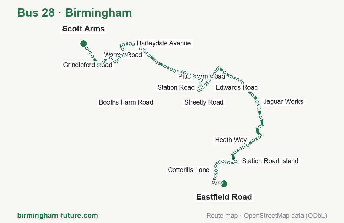
Route at a glance
| Mode | Bus |
|---|---|
| Route number | 28 |
| City | Birmingham |
| Operator | National Express West Midlands |
| Start → end | Eastfield Road → Scott Arms |
| End → start | Scott Arms → Eastfield Road |
| Route length | 20.6 km / 20.1 km in the opposite direction |
| Number of stops | 64 / 63 in the opposite direction |
| Travel time | about 65 minutes |
| Trips per day | 63 on weekdays, 33 on weekends one way |
| Frequency | peak 15 · midday 15 · weekend 30 |
| First / last trip from «Eastfield Road» | 05:35 / 23:40 |
| First / last trip from «Scott Arms» | 05:01 / 23:26 |
| Fare | 3.00 £ (fare in effect since 28 June 2026) |
| Updated | August 22, 2026 |
Route of Bus 28
Outbound: Eastfield Road → Scott Arms
This direction has 64 stops and runs 20.6 km. The route passes Kenwood Road, Clock Garage, New Street, Hawthorn Road Shops. Below is the full list with the distance from the first stop.
| No. | Stop | From start | Note |
|---|---|---|---|
| 1 | Eastfield Road | 0.0 km | Terminus |
| 2 | Kenwood Road | 0.2 km | |
| 3 | Heartlands Hospital | 0.4 km | |
| 4 | Bordesley Green | 0.6 km | |
| 5 | Saltley Grammar School | 1.0 km | |
| 6 | Cotterills Lane | 1.3 km | |
| 7 | Pelham Road | 1.5 km | |
| 8 | Bankdale Road | 1.8 km | |
| 9 | Treaford Lane | 2.0 km | |
| 10 | Washwood Heath Academy | 2.3 km | |
| 11 | Station Road Island | 2.8 km | |
| 12 | Beaufort Avenue | 3.3 km | |
| 13 | Southbourne Avenue | 3.7 km | |
| 14 | Ventnor Avenue | 4.0 km | |
| 15 | Hodge Hill Common | 4.1 km | |
| 16 | Heath Way | 4.5 km | |
| 17 | Clock Garage | 4.8 km | |
| 18 | Berrandale Gardens | 5.5 km | |
| 19 | Tameside Drive | 6.1 km | |
| 20 | Tangmere Drive | 6.5 km | |
| 21 | Jaguar Works | 6.9 km | |
| 22 | Opus Aspect | 7.3 km | |
| 23 | Gunter Road | 7.8 km | |
| 24 | Pype Hayes Park | 8.2 km | |
| 25 | Little Pitts Close | 8.5 km | |
| 26 | Pitts Farm Road | 8.8 km | |
| 27 | Yenton Primary Sch | 9.2 km | |
| 28 | Kentmere Tower | 9.7 km | |
| 29 | Fairbourne Tower | 10.0 km | |
| 30 | Orchard Road | 10.2 km | |
| 31 | Edwards Road | 10.5 km | |
| 32 | New Street | 10.8 km | |
| 33 | Barnabas Road | 10.9 km | |
| 34 | Six Ways Island | 11.1 km | |
| 35 | Machin Road | 11.5 km | |
| 36 | Station Road | 11.8 km | |
| 37 | Marsh Lane | 12.0 km | |
| 38 | Hailsham Road | 12.2 km | |
| 39 | Anderson Road | 12.6 km | |
| 40 | Court Farm Road | 12.8 km | |
| 41 | Streetly Road | 13.2 km | |
| 42 | Bleak Hill Road | 13.3 km | |
| 43 | Dovedale Road | 13.5 km | |
| 44 | Buxton Road | 13.9 km | |
| 45 | Crossways | 14.4 km | |
| 46 | Warren Road | 14.9 km | |
| 47 | Hawthorn Road Shops | 15.2 km | |
| 48 | Atlantic Road | 15.4 km | |
| 49 | Birdbrook Road | 15.7 km | |
| 50 | Cavandale Avenue | 15.9 km | |
| 51 | Darleydale Avenue | 16.1 km | |
| 52 | Glenmead Road | 16.4 km | |
| 53 | Scarsdale Road | 16.8 km | |
| 54 | James Watt College | 17.1 km | |
| 55 | Beeches Road | 17.4 km | |
| 56 | Grindleford Road | 17.6 km | |
| 57 | Longstone Road | 18.0 km | |
| 58 | Monsal Road | 18.3 km | |
| 59 | Foden Road | 18.7 km | |
| 60 | Tower Hill | 19.0 km | |
| 61 | Booths Farm Road | 19.5 km | |
| 62 | Stanford Avenue | 19.8 km | |
| 63 | Old Walsall Road | 20.0 km | |
| 64 | Scott Arms | 20.6 km | Terminus |
Inbound: Scott Arms → Eastfield Road
This direction has 63 stops and runs 20.1 km. The route passes Old Walsall Road, Atlantic Road, Wilton Road, Berrandale Gardens. Below is the full list with the distance from the first stop.
| No. | Stop | From start | Note |
|---|---|---|---|
| 1 | Scott Arms | 0.0 km | Terminus |
| 2 | Old Walsall Road | 0.2 km | |
| 3 | Stanford Avenue | 0.6 km | |
| 4 | Booths Farm Road | 0.9 km | |
| 5 | The Towers | 1.4 km | |
| 6 | Foden Road | 1.6 km | |
| 7 | Thornbridge Avenue | 2.0 km | |
| 8 | Longstone Road | 2.4 km | |
| 9 | Grindleford Road | 2.7 km | |
| 10 | Beeches Road | 2.8 km | |
| 11 | James Watt College | 3.2 km | |
| 12 | Scarsdale Road | 3.5 km | |
| 13 | Malthouse Lane | 3.7 km | |
| 14 | Glenmead Road | 3.9 km | |
| 15 | Darleydale Avenue | 4.2 km | |
| 16 | Birdbrook Road | 4.5 km | |
| 17 | Atlantic Road | 5.0 km | |
| 18 | Hawthorn Road Shops | 5.1 km | |
| 19 | Warren Road | 5.5 km | |
| 20 | Hawthorn Road | 6.0 km | |
| 21 | Buxton Road | 6.4 km | |
| 22 | Dovedale Road | 6.7 km | |
| 23 | Perry Common Road | 7.1 km | |
| 24 | Streetly Road | 7.3 km | |
| 25 | Court Farm Road | 7.5 km | |
| 26 | Anderson Road | 7.8 km | |
| 27 | Hailsham Road | 8.1 km | |
| 28 | Gravelly Lane | 8.4 km | |
| 29 | Machin Road | 8.8 km | |
| 30 | Six Ways Island | 9.2 km | |
| 31 | Barnabas Road | 9.3 km | |
| 32 | Wilton Road | 9.6 km | |
| 33 | Orchard Road | 10.0 km | |
| 34 | Fairbourne Tower | 10.3 km | |
| 35 | The Yenton | 10.7 km | |
| 36 | Yenton Primary Sch | 11.0 km | |
| 37 | Berwood Gardens | 11.2 km | |
| 38 | Pitts Farm Road | 11.4 km | |
| 39 | Little Pitts Close | 11.7 km | |
| 40 | Pype Hayes Park | 12.1 km | |
| 41 | Marshbrook Road | 12.4 km | |
| 42 | Gunter Road | 12.7 km | |
| 43 | Opus Aspect | 12.9 km | |
| 44 | Jaguar Works | 13.6 km | |
| 45 | Tangmere Drive | 14.0 km | |
| 46 | Tameside Drive | 14.2 km | |
| 47 | Berrandale Gardens | 14.9 km | |
| 48 | Clock Garage | 15.7 km | |
| 49 | Heath Way | 16.0 km | |
| 50 | Hodge Hill Common | 16.5 km | |
| 51 | Ventnor Avenue | 16.7 km | |
| 52 | Southbourne Avenue | 17.0 km | |
| 53 | Washwood Heath Road | 17.5 km | |
| 54 | The Ward End | 17.8 km | |
| 55 | Treaford Lane | 18.1 km | |
| 56 | Bankdale Road | 18.3 km | |
| 57 | Alum Rock Road | 18.6 km | |
| 58 | Cotterills Lane | 18.8 km | |
| 59 | Saltley Grammar School | 19.0 km | |
| 60 | Bordesley Green | 19.3 km | |
| 61 | Heartlands Hospital | 19.5 km | |
| 62 | Kenwood Road | 19.8 km | |
| 63 | Eastfield Road | 20.1 km | Terminus |
Schedule and frequency
According to the official schedule from National Express West Midlands, the route runs 63 trips in one direction on a weekday, and 33 on a weekend day.
| Direction | Weekdays | Weekends and holidays |
|---|---|---|
| From «Eastfield Road» | 05:35 — 23:40 | 07:40 — 23:40 |
| From «Scott Arms» | 05:01 — 23:26 | 06:55 — 23:26 |
Frequency calculated from the departure table: in the morning peak buses run every 15 minutes; midday every 15 minutes; in the afternoon peak every 14–20; on weekends every 30 minutes.
Fare and payment
A single ride costs 3.00 £ — fare in effect since 28 June 2026. The same fare applies to National Express buses in Birmingham.
A single journey on a National Express bus costs £3.00 and is valid on one bus for one journey only — it gives no transfer. A multi-operator nBus day ticket costs £5.50 and works on every operator in the scheme.
Frequently asked questions
How much does a ride on bus 28 cost?
3.00 £ for a single ride — fare in effect since 28 June 2026.
When do the first and last trips run?
From Eastfield Road the first is at 05:35 and the last at 23:40. From Scott Arms they are 05:01 and 23:26.
How long does the trip from Eastfield Road to Scott Arms take?
About 65 minutes end to end — the median of full trips in the official schedule.
How many stops does the route have?
64 outbound and 63 inbound according to the official GTFS feed. The two lists do not match exactly.
Does bus 28 run on weekends?
Yes. On weekends and holidays there are 33 trips in one direction, running from Eastfield Road between 07:40 and 23:40.
Every route number with its termini, operating hours and travel time is collected in the Birmingham buses overview.
Data current as of August 22, 2026. Schedule and termini — National Express West Midlands. Fares — National Express West Midlands. Stop list, schedule and route geometry come from the official GTFS feed (Bus Open Data Service (BODS)).