

Bus 5 in Birmingham links Moor Street Station and Solihull Town Centre. The route is 23.1 km long with 67 stops, and the official schedule from National Express West Midlands puts the full trip at about 73 minutes. On a weekday it runs 107 trips in one direction, and 63 on a weekend day.
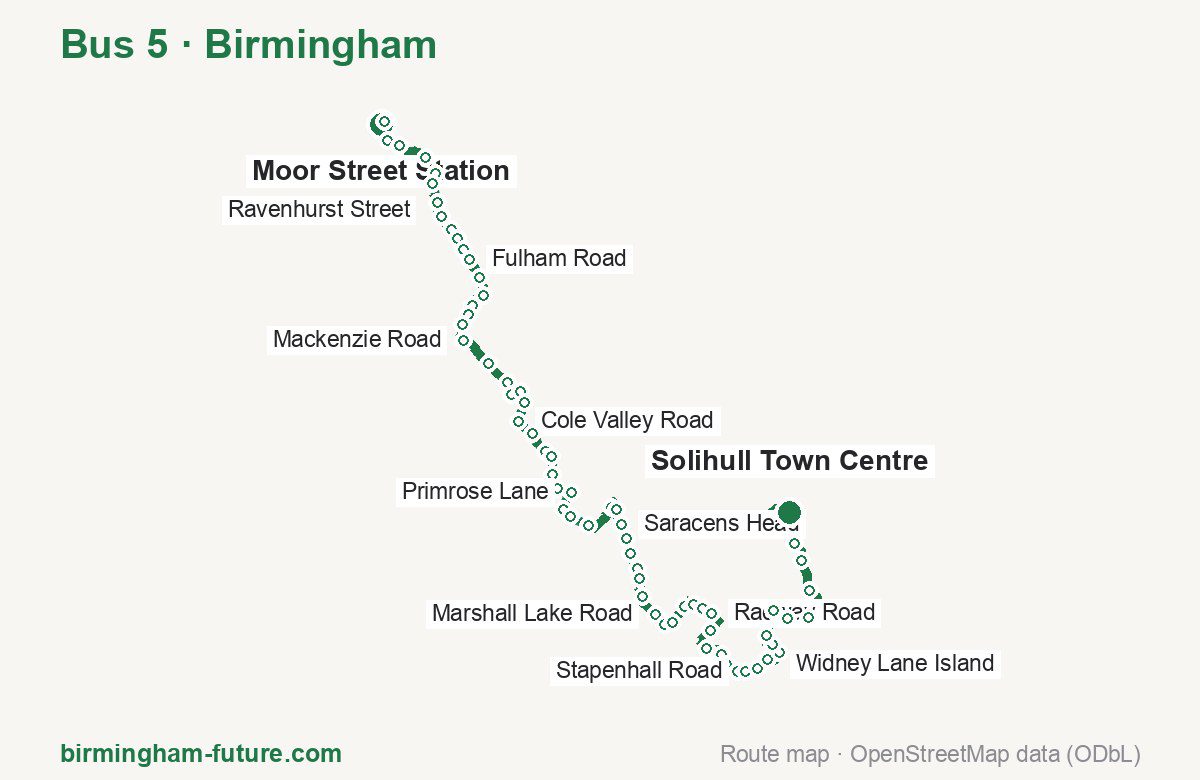
Route at a glance
| Mode | Bus |
|---|---|
| Route number | 5 |
| City | Birmingham |
| Operator | National Express West Midlands |
| Start → end | Moor Street Station → Solihull Town Centre |
| End → start | Solihull Town Centre → Moor Street Station |
| Route length | 23.1 km / 22.2 km in the opposite direction |
| Number of stops | 67 / 63 in the opposite direction |
| Travel time | about 73 minutes |
| Trips per day | 107 on weekdays, 63 on weekends one way |
| Frequency | peak 1–12 · midday 1–12 · weekend 5–30 |
| First / last trip from «Moor Street Station» | 05:05 / 23:55 |
| First / last trip from «Solihull Town Centre» | 05:28 / 23:37 |
| Fare | 3.00 £ (fare in effect since 28 June 2026) |
| Updated | August 22, 2026 |
Route of Bus 5
Outbound: Moor Street Station → Solihull Town Centre
This direction has 67 stops and runs 23.1 km. The route passes Bus Mall, Eileen Road, Skelcher Road, Solihull Business Park. Below is the full list with the distance from the first stop.
| No. | Stop | From start | Note |
|---|---|---|---|
| 1 | Moor Street Station | 0.0 km | Terminus |
| 2 | Bus Mall | 0.2 km | |
| 3 | Allison Street | 0.7 km | |
| 4 | Birmingham Coach Station | 1.0 km | |
| 5 | Adderley Street | 1.5 km | |
| 6 | Trinity Terrace | 1.9 km | |
| 7 | Ravenhurst Street | 2.1 km | |
| 8 | Auckland Road | 2.5 km | |
| 9 | Main Street | 2.7 km | |
| 10 | Ludlow Court | 3.0 km | |
| 11 | Palmerston Road | 3.2 km | |
| 12 | Poplar Road | 3.5 km | |
| 13 | Fulham Road | 3.7 km | |
| 14 | Baker Street | 4.1 km | |
| 15 | Frederick Road | 4.5 km | |
| 16 | Phipson Road | 4.8 km | |
| 17 | Bridge Close | 5.0 km | |
| 18 | Eileen Road | 5.2 km | |
| 19 | Mackenzie Road | 5.5 km | |
| 20 | Berkley Crescent | 6.2 km | |
| 21 | Gracewell Road | 6.7 km | |
| 22 | Thirlmere Drive | 6.9 km | |
| 23 | Sarehole Mill | 7.1 km | |
| 24 | Southam Road | 7.4 km | |
| 25 | Cole Valley Road | 7.8 km | |
| 26 | Sherwood Road | 8.2 km | |
| 27 | Highfield Road Island | 8.6 km | |
| 28 | Etwall Road | 8.8 km | |
| 29 | Doveridge Road | 9.2 km | |
| 30 | Dalbury Road | 9.4 km | |
| 31 | Primrose Lane | 9.8 km | |
| 32 | The Baldwin | 10.2 km | |
| 33 | Blythsford Road | 10.4 km | |
| 34 | Skelcher Road | 10.7 km | |
| 35 | Trinity Way | 11.4 km | |
| 36 | Jacey Road | 11.7 km | |
| 37 | Saracens Head | 11.9 km | |
| 38 | Longmore Road | 12.2 km | |
| 39 | St James Church | 12.5 km | |
| 40 | Union Road | 12.8 km | |
| 41 | Bishopton Close | 13.0 km | |
| 42 | Harwood Grove | 13.4 km | |
| 43 | Marshall Lake Road | 13.8 km | |
| 44 | Connaught House | 14.1 km | |
| 45 | Swallows Meadow | 14.3 km | |
| 46 | Maidwell Drive | 14.7 km | |
| 47 | Cranmore Avenue | 14.9 km | |
| 48 | Stirling Road | 15.1 km | |
| 49 | Radway Road | 15.3 km | |
| 50 | Solihull Business Park | 15.7 km | |
| 51 | Cranbrook Way | 16.1 km | |
| 52 | Rainsbrook Drive | 16.5 km | |
| 53 | Palefield Road | 16.7 km | |
| 54 | Kemerton Way | 17.0 km | |
| 55 | Stapenhall Road | 17.1 km | |
| 56 | Rowthorn Drive | 17.4 km | |
| 57 | Shelly Lane | 17.7 km | |
| 58 | Kettlebrook Road | 18.0 km | |
| 59 | Farmhouse Way | 18.2 km | |
| 60 | Hillfield Park | 18.5 km | |
| 61 | Widney Lane Island | 19.1 km | |
| 62 | Stonebow Avenue | 19.4 km | |
| 63 | Widney Manor Station | 19.9 km | |
| 64 | Deer Park Way | 20.6 km | |
| 65 | Solihull Sixth Form College | 21.2 km | |
| 66 | Whitefields Road | 21.6 km | |
| 67 | Solihull Town Centre | 23.1 km | Terminus |
Inbound: Solihull Town Centre → Moor Street Station
This direction has 63 stops and runs 22.2 km. The route passes Whitefields Road, Solihull Business Park, Haslucks Croft, Astor Drive. Below is the full list with the distance from the first stop.
| No. | Stop | From start | Note |
|---|---|---|---|
| 1 | Solihull Town Centre | 0.0 km | Terminus |
| 2 | Whitefields Road | 1.3 km | |
| 3 | Solihull Sixth Form College | 1.7 km | |
| 4 | Deer Park Way | 2.1 km | |
| 5 | Widney Manor Station | 2.8 km | |
| 6 | Stonebow Avenue | 3.3 km | |
| 7 | Knightcote Drive | 3.6 km | |
| 8 | Hillfield Park | 4.0 km | |
| 9 | Farmhouse Way | 4.4 km | |
| 10 | Kettlebrook Road | 4.5 km | |
| 11 | Elmbridge Drive | 4.7 km | |
| 12 | Hawbridge Close | 5.0 km | |
| 13 | Kemerton Way | 5.6 km | |
| 14 | Palefield Road | 5.9 km | |
| 15 | Rainsbrook Drive | 6.1 km | |
| 16 | Cranbrook Way | 6.5 km | |
| 17 | Solihull Business Park | 6.8 km | |
| 18 | Radway Road | 7.2 km | |
| 19 | Stirling Road | 7.5 km | |
| 20 | Cranmore Avenue | 7.8 km | |
| 21 | Maidwell Drive | 7.8 km | |
| 22 | Swallows Meadow | 8.2 km | |
| 23 | Connaught House | 8.6 km | |
| 24 | Blackford Road | 9.0 km | |
| 25 | Harwood Grove | 9.2 km | |
| 26 | Bishopton Close | 9.6 km | |
| 27 | School Road | 9.9 km | |
| 28 | St James Church | 10.2 km | |
| 29 | Saracens Head | 10.6 km | |
| 30 | Jacey Road | 11.0 km | |
| 31 | Trinity Way | 11.1 km | |
| 32 | Haslucks Croft | 11.6 km | |
| 33 | Blythsford Road | 12.1 km | |
| 34 | The Baldwin | 12.4 km | |
| 35 | Primrose Lane | 12.7 km | |
| 36 | Dalbury Road | 13.1 km | |
| 37 | Doveridge Road | 13.5 km | |
| 38 | Etwall Road | 13.7 km | |
| 39 | Highfield Road Island | 13.9 km | |
| 40 | Sherwood Road | 14.3 km | |
| 41 | Webb Lane | 14.5 km | |
| 42 | Cole Valley Road | 14.8 km | |
| 43 | Southam Road | 15.0 km | |
| 44 | Cole Bank Road | 15.3 km | |
| 45 | Sarehole Mill | 15.5 km | |
| 46 | Gracewell Road | 15.8 km | |
| 47 | Astor Drive | 16.5 km | |
| 48 | Mackenzie Road | 16.8 km | |
| 49 | Woodlands Road | 17.3 km | |
| 50 | Bridge Close | 17.6 km | |
| 51 | Phipson Road | 17.9 km | |
| 52 | Baker Street | 18.4 km | |
| 53 | Fulham Road | 18.6 km | |
| 54 | Poplar Road | 18.9 km | |
| 55 | Palmerston Road | 19.2 km | |
| 56 | Ludlow Court | 19.4 km | |
| 57 | Main Street | 19.6 km | |
| 58 | Auckland Road | 19.9 km | |
| 59 | Ravenhurst Street | 20.4 km | |
| 60 | Adderley Street | 21.0 km | |
| 61 | Birmingham Coach Station | 21.5 km | |
| 62 | Park Street | 21.8 km | |
| 63 | Moor Street Station | 22.2 km | Terminus |
Schedule and frequency
According to the official schedule from National Express West Midlands, the route runs 107 trips in one direction on a weekday, and 63 on a weekend day.
| Direction | Weekdays | Weekends and holidays |
|---|---|---|
| From «Moor Street Station» | 05:05 — 23:55 | 07:20 — 23:55 |
| From «Solihull Town Centre» | 05:28 — 23:37 | 08:05 — 23:37 |
Frequency calculated from the departure table: in the morning peak buses run every 1–12 minutes, most often every 11; midday every 1–12 minutes; in the afternoon peak every 1–25; on weekends every 5–30 minutes.
Fare and payment
A single ride costs 3.00 £ — fare in effect since 28 June 2026. The same fare applies to National Express buses in Birmingham.
A single journey on a National Express bus costs £3.00 and is valid on one bus for one journey only — it gives no transfer. A multi-operator nBus day ticket costs £5.50 and works on every operator in the scheme.
Frequently asked questions
How much does a ride on bus 5 cost?
3.00 £ for a single ride — fare in effect since 28 June 2026.
When do the first and last trips run?
From Moor Street Station the first is at 05:05 and the last at 23:55. From Solihull Town Centre they are 05:28 and 23:37.
How long does the trip from Moor Street Station to Solihull Town Centre take?
About 73 minutes end to end — the median of full trips in the official schedule.
How many stops does the route have?
67 outbound and 63 inbound according to the official GTFS feed. The two lists do not match exactly.
Does bus 5 run on weekends?
Yes. On weekends and holidays there are 63 trips in one direction, running from Moor Street Station between 07:20 and 23:55.
Every route number with its termini, operating hours and travel time is collected in the Birmingham buses overview.
Data current as of August 22, 2026. Schedule and termini — National Express West Midlands. Fares — National Express West Midlands. Stop list, schedule and route geometry come from the official GTFS feed (Bus Open Data Service (BODS)).